
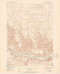
1950 Map of Huddle Table
USGS Topo · Published 1950About this map
The Niobrara River carves a deep valley through this mid-century landscape on the border of Keya Paha Co and Brown Co. This 1950 edition captures a predominantly agrarian frontier character, defined by the specific family names associated with the local ranching economy. Prominent landholdings like the Johnny Kirkpatrick Ranch and Hurlbut Ranch are situated along the river's fertile banks, while the upland terrain is marked by distinct plateaus like Huddle Table. The distribution of community centers such as Union Ch and numerous rural educational sites, including Turkey Creek Sch and School No 9, reflects a time when small-scale district schools still served the scattered residents of Garfield and Fairfield townships. Significant local landmarks like Hartman Island and the erosion patterns of Buzzard Canyon illustrate the unique geography of northern Nebraska before the widespread consolidation of rural infrastructure.
Find a feature on this map
29 named features on this map. Tap any name to fly to it.
Don’t see what you’re looking for? This feature index may not catch every label — zoom into the map to look around manually.
Map Details
Editions of this 1950 Huddle Table Map
2 editions found
Other maps of this area

1949 · Dutch Creek
USGS Topo · 1:24,000

1950 · Norden
USGS Topo · 1:62,500

1950 · Meadville
USGS Topo · 1:24,000

1950 · Dutch Creek
USGS Topo · 1:24,000

1950 · Wood Lake
USGS Topo · 1:62,500

1952 · Norden
USGS Topo · 1:62,500

1954 · Ainsworth NW
USGS Topo · 1:24,000

1955 · O'Neill
USGS Topo · 1:250,000

1957 · Valentine
USGS Topo · 1:250,000

1959 · Valentine
USGS Topo · 1:250,000