
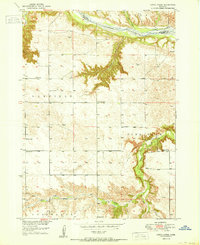
1950 Map of Dutch Creek
USGS Topo · Published 1950About this map
The Niobrara River carves a deep valley across this northern Nebraska landscape, marking the boundary between Keya Paha and Brown counties. In the late 1940s, this rural area was defined by a scattered network of one-room schoolhouses and small community centers. Cultural landmarks like Highland Ch and the Lessig Cem serve as focal points for the townships of Garfield, Pine Glen, and Ainsworth. The terrain is deeply incised by drainages such as Devils Gulch and Dutch Creek, which feed into the primary river system. Local education is anchored by numerous named facilities, including Jones Sch, Park Row Sch, and School No 11. This mapping project was conducted as part of the Department of the Interior's post-war program for the development of the Missouri River Basin, documenting the elevation and water resources of these prairie uplands.
Find a feature on this map
18 named features on this map. Tap any name to fly to it.
Don’t see what you’re looking for? This feature index may not catch every label — zoom into the map to look around manually.
Map Details
Editions of this 1950 Dutch Creek Map
2 editions found
Other maps of this area

1949 · Dutch Creek
USGS Topo · 1:24,000

1950 · Bassett NW
USGS Topo · 1:24,000

1950 · Meadville
USGS Topo · 1:24,000

1950 · Huddle Table
USGS Topo · 1:24,000

1954 · Ainsworth NW
USGS Topo · 1:24,000

1954 · Ainsworth SW
USGS Topo · 1:24,000

1954 · Ainsworth
USGS Topo · 1:24,000

1954 · Long Pine
USGS Topo · 1:24,000

1955 · O'Neill
USGS Topo · 1:250,000

1959 · O'Neill
USGS Topo · 1:250,000