
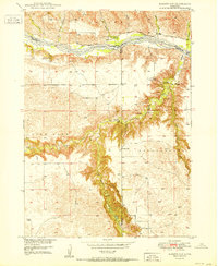
1950 Map of Bassett NW
USGS Topo · Published 1950About this map
The Niobrara River carves through the northern reaches of this mid-century Nebraska landscape, marking the convergence of Brown, Rock, and Keya Paha counties. The terrain transitions from the river valley into the high tablelands of Custer and Pine Glen, where the drainage patterns of Long Pine Creek and Bone Creek have created a complex network of canyons and draws, including Devils Canyon.
Find a feature on this map
29 named features on this map. Tap any name to fly to it.
Don’t see what you’re looking for? This feature index may not catch every label — zoom into the map to look around manually.
Map Details
Editions of this 1950 Bassett NW Map
2 editions found
Other maps of this area

1949 · Dutch Creek
USGS Topo · 1:24,000

1949 · Riverview
USGS Topo · 1:24,000

1950 · Riverview
USGS Topo · 1:24,000

1950 · Meadville
USGS Topo · 1:24,000

1950 · Dutch Creek
USGS Topo · 1:24,000

1954 · Ainsworth
USGS Topo · 1:24,000

1954 · Long Pine
USGS Topo · 1:24,000

1954 · Bassett
USGS Topo · 1:24,000

1955 · O'Neill
USGS Topo · 1:250,000

1959 · O'Neill
USGS Topo · 1:250,000