
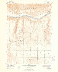
1950 Map of Riverview
USGS Topo · Published 1950About this map
The Niobrara River carves a deep valley through the Nebraska Sandhills, serving as the dominant geographic feature of this mid-century landscape. This survey captures the isolated settlement of Riverview on the north bank, situated near the county line where Keya Paha and Rock Counties meet. The braided river channel is dotted with landmarks like Kindall Island and is fed by numerous drainages including Wyman, Elk, and Sand Creeks.
Find a feature on this map
19 named features on this map. Tap any name to fly to it.
Don’t see what you’re looking for? This feature index may not catch every label — zoom into the map to look around manually.
Map Details
Editions of this 1950 Riverview Map
2 editions found
Other maps of this area

1949 · Jamison SW
USGS Topo · 1:24,000

1949 · Riverview
USGS Topo · 1:24,000

1949 · Carns
USGS Topo · 1:24,000

1950 · Bassett NW
USGS Topo · 1:24,000

1950 · Carns
USGS Topo · 1:24,000

1951 · Jamison SW
USGS Topo · 1:24,000

1954 · Long Pine
USGS Topo · 1:24,000

1954 · Bassett
USGS Topo · 1:24,000

1954 · Newport SW
USGS Topo · 1:24,000

1955 · O'Neill
USGS Topo · 1:250,000