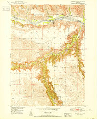
1950 Map of Bassett NW
USGS Topo · Published 1950About this map
The Niobrara River carves a complex path through this corner of Brown County, where the transition from flat tablelands to deep drainage canyons defines the local geography. In the mid-twentieth century, this landscape was dotted with rural social hubs, including the Cuba Ch and scattered educational sites like School No 26, School No 29, and the Winfield Sch. The topography reveals the dramatic erosion patterns of Long Pine Creek and Devils Canyon Creek as they cut through the Pine Glen and Brinkerhoff regions. Genealogists will find significant value in the documentation of family-named landmarks and resting places, such as the Leonard Cem, Hulshizer Cem, and Putnam Cem. A Gaging Station and the Camp Meeting Ground further reflect the area's historical reliance on and gathering around its vital water resources.
Find a feature on this map
31 named features on this map. Tap any name to fly to it.
Don’t see what you’re looking for? This feature index may not catch every label — zoom into the map to look around manually.
Map Details
Editions of this 1950 Bassett NW Map
2 editions found
Other maps of this area

1949 · Dutch Creek
USGS Topo · 1:24,000

1949 · Riverview
USGS Topo · 1:24,000

1950 · Bassett NW
USGS Topo · 1:24,000

1950 · Riverview
USGS Topo · 1:24,000

1950 · Meadville
USGS Topo · 1:24,000

1950 · Dutch Creek
USGS Topo · 1:24,000

1954 · Ainsworth
USGS Topo · 1:24,000

1954 · Long Pine
USGS Topo · 1:24,000

1954 · Bassett
USGS Topo · 1:24,000

1955 · O'Neill
USGS Topo · 1:250,000