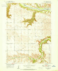
1950 Map of Dutch Creek
USGS Topo · Published 1950About this map
The Niobrara River carves a deep valley across the northern boundary of this Nebraska landscape, where the border between Keya Paha and Brown counties follows the winding water. The terrain is defined by dramatic erosion, notably at Devils Gulch and the winding course of Dutch Creek and Bone Creek. This mid-century survey reveals a rural society organized around a network of one-room schoolhouses and community landmarks. Educational nodes like Park Row Sch and Jones Sch are scattered across the townships of Garfield, Pine Glen, and Ainsworth. Genealogists will find particular value in the location of the Lessig Cem and the Highland Ch, which served the families working the nearby draws and tablelands. Windmills are frequently noted, marking the essential water infrastructure of this agricultural era.
Find a feature on this map
18 named features on this map. Tap any name to fly to it.
Don’t see what you’re looking for? This feature index may not catch every label — zoom into the map to look around manually.
Map Details
Editions of this 1950 Dutch Creek Map
2 editions found
Other maps of this area

1949 · Dutch Creek
USGS Topo · 1:24,000

1950 · Bassett NW
USGS Topo · 1:24,000

1950 · Meadville
USGS Topo · 1:24,000

1950 · Huddle Table
USGS Topo · 1:24,000

1950 · Dutch Creek
USGS Topo · 1:24,000

1954 · Ainsworth NW
USGS Topo · 1:24,000

1954 · Ainsworth SW
USGS Topo · 1:24,000

1954 · Ainsworth
USGS Topo · 1:24,000

1954 · Long Pine
USGS Topo · 1:24,000

1955 · O'Neill
USGS Topo · 1:250,000