
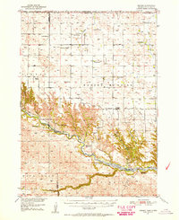
1950 Map of Norden
USGS Topo · Published 1950About this map
The Niobrara River carves a deep valley across the central portion of this 1950 survey, marking the transition between the sandhills and the rugged canyons of the north. The small settlement of Norden serves as a local hub, situated between Norden West Cem and Norden East Cem. This landscape is defined by its ranching heritage, with family-named spreads like Worth Ranch, Keogh Ranch, and Schiffern Ranch scattered throughout the territory.
Find a feature on this map
44 named features on this map. Tap any name to fly to it.
Don’t see what you’re looking for? This feature index may not catch every label — zoom into the map to look around manually.
Map Details
Editions of this 1950 Norden Map
2 editions found
Other maps of this area

1950 · Huddle Table
USGS Topo · 1:24,000

1950 · Sparks
USGS Topo · 1:62,500

1950 · Wood Lake
USGS Topo · 1:62,500

1950 · Arabia
USGS Topo · 1:62,500

1952 · Norden
USGS Topo · 1:62,500

1954 · Ainsworth NW
USGS Topo · 1:24,000

1955 · Martin
USGS Topo · 1:250,000

1955 · Mitchell
USGS Topo · 1:250,000

1955 · O'Neill
USGS Topo · 1:250,000

1957 · Valentine
USGS Topo · 1:250,000