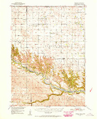
1950 Map of Norden
USGS Topo · Published 1956About this map
The Niobrara River carves a deep valley across this landscape, marking the boundary between Keya Paha and Brown counties during the early 1950s. The settlement of Norden serves as a central point, flanked by the Norden West and Norden East cemeteries. This era shows a high density of rural school districts, including the Rockford School and numerous numbered districts like School No 48, though several such as School No 12 were already noted as abandoned by the time of the survey.
Find a feature on this map
38 named features on this map. Tap any name to fly to it.
Don’t see what you’re looking for? This feature index may not catch every label — zoom into the map to look around manually.
Map Details
Editions of this 1950 Norden Map
2 editions found
Other maps of this area

1950 · Norden
USGS Topo · 1:62,500

1950 · Huddle Table
USGS Topo · 1:24,000

1950 · Sparks
USGS Topo · 1:62,500

1950 · Wood Lake
USGS Topo · 1:62,500

1950 · Arabia
USGS Topo · 1:62,500

1952 · Norden
USGS Topo · 1:62,500

1954 · Ainsworth NW
USGS Topo · 1:24,000

1955 · Martin
USGS Topo · 1:250,000

1955 · Mitchell
USGS Topo · 1:250,000

1955 · O'Neill
USGS Topo · 1:250,000