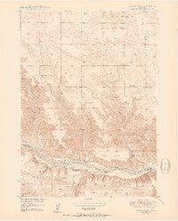
1950 Map of Huddle Table
USGS Topo · Published 1950About this map
The Niobrara River carves through the heart of this landscape, creating a distinct boundary between the northern plateaus and the southern canyons. In the post-war years, this area on the line between Keya Paha and Brown Counties was defined by scattered cattle operations and rural infrastructure. Local life centered on family holdings such as the Johnny Kirkpatrick Ranch, Hurlbut Ranch, and Chase Ranch. This 1950 edition illustrates a network of small schoolhouses, including Turkey Creek Sch, Pine Knoll Sch, and School No 8, which served the isolated residents of Huddle Table. The presence of the Union Ch and various windmills indicates the reliance on community hubs and groundwater management for sustaining the local ranching economy. Significant drainage features like Turkey Creek and Buzzard Canyon highlight the complex topography surrounding the central river valley.
Find a feature on this map
27 named features on this map. Tap any name to fly to it.
Don’t see what you’re looking for? This feature index may not catch every label — zoom into the map to look around manually.
Map Details
Editions of this 1950 Huddle Table Map
2 editions found
Other maps of this area

1949 · Dutch Creek
USGS Topo · 1:24,000

1950 · Norden
USGS Topo · 1:62,500

1950 · Meadville
USGS Topo · 1:24,000

1950 · Huddle Table
USGS Topo · 1:24,000

1950 · Dutch Creek
USGS Topo · 1:24,000

1950 · Wood Lake
USGS Topo · 1:62,500

1952 · Norden
USGS Topo · 1:62,500

1954 · Ainsworth NW
USGS Topo · 1:24,000

1955 · O'Neill
USGS Topo · 1:250,000

1957 · Valentine
USGS Topo · 1:250,000