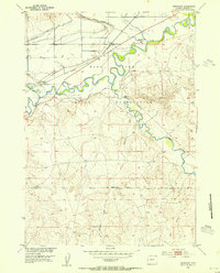
1953 Map of Arapahoe
USGS Topo · Published 1954About this map
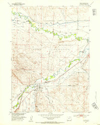
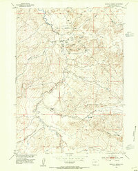
The Wind River Indian Reservation landscape is defined by the convergence of the Wind River and the Popo Agie River in central Wyoming. The 1953 environment shown here is one of carefully managed water, where an extensive network of irrigation infrastructure including the Sub-Agency Ditch, Lefthand Ditch, and Mission Ditch supports agricultural activity across the river valleys. The settlement at Arapahoe serves as a local hub near the Chicago and North Western rail line, which cuts across the northern portion of the quadrangle. Significant cultural sites are present, notably the Indian Burial Ground and the community of St Stephens near the river bend. The terrain transitions from the verdant river bottoms to more dissected landscape features like Preacher Draw and Beaver Creek to the south, illustrating the complex hydrology of the Fremont County area during the mid-20th century.
Find a feature on this map
19 named features on this map. Tap any name to fly to it.
Don’t see what you’re looking for? This feature index may not catch every label — zoom into the map to look around manually.
Map Details
Editions of this 1953 Arapahoe Map
This is the sole edition of this map. No revisions or reprints were ever made.
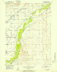
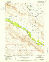
Other maps of this area
1950 · Riverton East
USGS Topo · 1:24,000
1951 · Pavillion SE
USGS Topo · 1:24,000
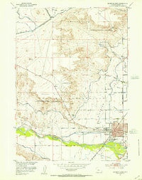
1951 · Riverton West
USGS Topo · 1:24,000
1952 · Hudson
USGS Topo · 1:24,000
1952 · Lander SE
USGS Topo · 1:24,000
1953 · Arapahoe NE
USGS Topo · 1:24,000
1953 · Ninemile Hill
USGS Topo · 1:24,000
1953 · Bringolf Ranch
USGS Topo · 1:24,000

1955 · Thermopolis
USGS Topo · 1:250,000

1955 · Lander
USGS Topo · 1:250,000