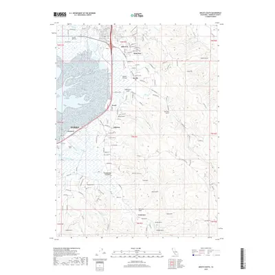
2018 Map of Arcata South
USGS Topo · Published 2018About this map
Arcata and the northern reaches of Eureka anchor this coastal landscape where the waters of Humboldt Bay meet a complex network of sloughs and gulches. The transition from the low-lying Arcata Bottoms and Bayside Bottoms to the timbered ridges of Fickle Hill is marked by a series of small communities including Sunny Brae, Bayside, and Freshwater. The transportation corridor is defined by the Northwestern Pacific RR and roads like Vaissade Rd, which navigate the marshy margins of Gannon Slough and McDaniel Slough. Notable landmarks include Murray Field and the winding course of Jacoby Creek, which drains into the bay near Bracut. This 2018 survey detail provides a look at the suburban expansion and industrial infrastructure that has shaped the eastern shore of the bay, from the residential streets of Arcata to the gulches like Rocky Gulch and Washington Gulch that cut through the coastal foothills.
Find a feature on this map
129 named features on this map. Tap any name to fly to it.
Don’t see what you’re looking for? This feature index may not catch every label — zoom into the map to look around manually.
Map Details
Editions of this 2018 Arcata South Map
This is the sole edition of this map. No revisions or reprints were ever made.
Other maps of this area

1922 · Eureka
USGS Topo · 1:62,500

1922 · Korbel
USGS Topo · 1:62,500

1922 · Kneeland
USGS Topo · 1:62,500

1933 · Eureka
USGS Topo · 1:48,000

1942 · Eureka
USGS Topo · 1:62,500

1944 · Fortuna
USGS Topo · 1:62,500

1945 · Blue Lake
USGS Topo · 1:62,500

1949 · Eureka
USGS Topo · 1:250,000

1950 · Iaqua Buttes
USGS Topo · 1:62,500

1951 · Eureka
USGS Topo · 1:62,500