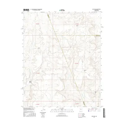
2017 Map of Arch Mesa
USGS Topo · Published 2017About this map
Arch Mesa and Piedra Lumbre anchor this high-elevation landscape where the boundaries of Sandoval, Cibola, and Bernalillo counties converge. The terrain is defined by a series of prominent mesas and the deeply carved watercourses that drain them, including the Cañada de San Antonio and Cañada los Apaches. These intermittent streams dictate the movement across the land, as seen with the Laguna Tribal Rd and Sandoval Rd navigating the contours of the mesa slopes.
Find a feature on this map
25 named features on this map. Tap any name to fly to it.
Don’t see what you’re looking for? This feature index may not catch every label — zoom into the map to look around manually.
Map Details
Editions of this 2017 Arch Mesa Map
This is the sole edition of this map. No revisions or reprints were ever made.
Other maps of this area

1883 · Mt. Taylor
USGS Topo · 1:250,000

1886 · Mt. Taylor
USGS Topo · 1:250,000

1892 · Mt. Taylor
USGS Topo · 1:250,000

1899 · Mt. Taylor
USGS Topo · 1:250,000

1954 · Herrera
USGS Topo · 1:24,000

1954 · Canoncito School
USGS Topo · 1:24,000
1957 · Mesa Gigante
USGS Topo · 1:24,000

1957 · Moquino
USGS Topo · 1:24,000

1957 · Mesita
USGS Topo · 1:24,000
1957 · Arch Mesa
USGS Topo · 1:24,000