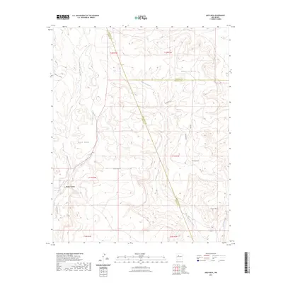
2023 Map of Arch Mesa
USGS Topo · Published 2023About this map
Piedra Lumbre serves as the primary named settlement in this high-desert landscape, situated where the Arroyo de Piedra Lumbre cuts through the western mesas. The topography is defined by a series of significant flat-topped formations, including Herrera Mesa, Arch Mesa, and Plate Mesa, which dominate the central and eastern sections of the quadrangle. These geological features are separated by a network of drainage systems such as Arroyo Zilo and Cañada de San Antonio.
Find a feature on this map
26 named features on this map. Tap any name to fly to it.
Don’t see what you’re looking for? This feature index may not catch every label — zoom into the map to look around manually.
Map Details
Editions of this 2023 Arch Mesa Map
This is the sole edition of this map. No revisions or reprints were ever made.
Other maps of this area

1883 · Mt. Taylor
USGS Topo · 1:250,000

1886 · Mt. Taylor
USGS Topo · 1:250,000

1892 · Mt. Taylor
USGS Topo · 1:250,000

1899 · Mt. Taylor
USGS Topo · 1:250,000

1954 · Herrera
USGS Topo · 1:24,000

1954 · Canoncito School
USGS Topo · 1:24,000
1957 · Mesa Gigante
USGS Topo · 1:24,000

1957 · Moquino
USGS Topo · 1:24,000

1957 · Mesita
USGS Topo · 1:24,000
1957 · Arch Mesa
USGS Topo · 1:24,000