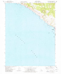
1977 Map of Arched Rock
USGS Topo · Published 1978About this map
Sonoma Coast State Beach and its distinctive shoreline dominate this survey, where the Russian River meets the Pacific Ocean just north of Bodega Bay. The landscape is characterized by steep coastal bluffs and deep drainages like Russian Gulch, Jewell Gulch, and Timber Gulch, which cut through the high ground rising toward Little Black Mtn. These geological formations, including the prominent namesake Arched Rock and the nearby Goat Rock, highlight the erosional forces at work along the Sonoma coast.
Find a feature on this map
20 named features on this map. Tap any name to fly to it.
Don’t see what you’re looking for? This feature index may not catch every label — zoom into the map to look around manually.
Map Details
Editions of this 1977 Arched Rock Map
2 editions found
Other maps of this area

1921 · Skaggs
USGS Topo · 1:62,500

1921 · Plantation
USGS Topo · 1:62,500

1942 · Bodega Head
USGS Topo · 1:24,000

1942 · Arched Rock
USGS Topo · 1:24,000

1943 · Plantation
USGS Topo · 1:24,000

1943 · Cazadero
USGS Topo · 1:24,000

1943 · Duncans Mills
USGS Topo · 1:24,000

1943 · Fort Ross
USGS Topo · 1:24,000
1944 · Fort Ross
USGS Topo · 1:31,680
1944 · Plantation
USGS Topo · 1:31,680