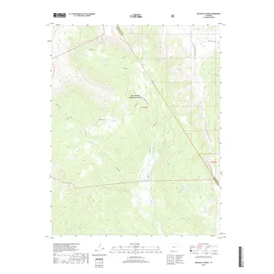
2019 Map of Archuleta Creek
USGS Topo · Published 2019About this map
The Rio Grande National Forest landscape is defined by the high-elevation headwaters of the Chama River system near the border of Archuleta and Conejos counties. The terrain is marked by the convergence of the W Fork Rio Chama and E Fork Rio Chama, which drain the steep alpine slopes of the Archuleta massif. This region serves as a critical hydrologic and recreational corridor, centered around the Continental Divide National Scenic Trail as it traverses the eastern ridgeline. A concentration of high-country water bodies, including Chama Lake, Crater Lake, and Mystery Lake, illustrates the glaciated character of the San Juan Mountains. Historical access into this wilderness is traced via the Hughes Trail and the Red Lake Cutoff, reflecting the long-established path-finding required to navigate this portion of the Continental Divide.
Find a feature on this map
24 named features on this map. Tap any name to fly to it.
Don’t see what you’re looking for? This feature index may not catch every label — zoom into the map to look around manually.
Map Details
Editions of this 2019 Archuleta Creek Map
This is the sole edition of this map. No revisions or reprints were ever made.
Other maps of this area

1913 · Summitville
USGS Topo · 1:125,000

1915 · Summitville
USGS Topo · 1:125,000

1918 · Tusas
USGS Topo · 1:125,000

1922 · Conejos
USGS Topo · 1:125,000

1945 · Durango
USGS Topo · 1:250,000

1953 · Durango
USGS Topo · 1:250,000

1954 · Durango
USGS Topo · 1:250,000

1954 · Aztec
USGS Topo · 1:250,000

1955 · Chama
USGS Topo · 1:62,500

1955 · Brazos Peak
USGS Topo · 1:62,500