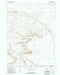
1991 Map of Arcola
USGS Topo · Published 1995About this map
Chalk Bluffs dominate the central landscape of this borderland survey, marking the dramatic transition between the high plains of Wyoming and Colorado. The settlement of Arcola sits along an Old Railroad Grade that traces the valley of Crow Creek, indicating a legacy of steam-era transportation through this arid corridor. The terrain is defined by its drainages, including Porter Creek, and the remnants of resource extraction shown by a Gravel Pit and scattered Drill Hole locations. This map reveals a high-plains environment where the state boundary between Laramie County and Weld County cuts across a sparsely populated region of ranching and early industrial exploration.
Find a feature on this map
10 named features on this map. Tap any name to fly to it.
Don’t see what you’re looking for? This feature index may not catch every label — zoom into the map to look around manually.
Map Details
Editions of this 1991 Arcola Map
This is the sole edition of this map. No revisions or reprints were ever made.
Other maps of this area

1908 · Eaton
USGS Topo · 1:125,000

1910 · Eaton
USGS Topo · 1:125,000

1911 · Cheyenne
USGS Topo · 1:125,000

1914 · Cheyenne
USGS Topo · 1:125,000

1954 · Cheyenne
USGS Topo · 1:250,000

1954 · Greeley
USGS Topo · 1:250,000

1957 · Greeley
USGS Topo · 1:250,000

1958 · Cheyenne
USGS Topo · 1:250,000

1958 · Greeley
USGS Topo · 1:250,000

1961 · Greeley
USGS Topo · 1:250,000