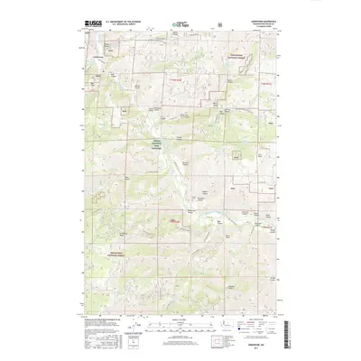
2017 Map of Ardenvoir
USGS Topo · Published 2017About this map
The Entiat River corridor defines the geography of this 2017 survey, where the river valley supports concentrated human activity amidst the expansive terrain of the Wenatchee National Forest. The settlement of Ardenvoir marks the junction where the Mad River meets the Entiat, serving as a gateway to the deep canyons and ridges that dominate the landscape. A notable concentration of specialized infrastructure is visible, including the Entiat National Fish Hatchery and the Entiat Ditch, illustrating how the waterway is managed for conservation and local utility. To the southeast, the Entiat Cem provides a point of genealogical interest near the river's bend. The topography is characterized by dramatic vertical relief, from the heights of Steliko Ridge and Dinkelman Ridge down into a complex system of drainages like Steliko Canyon, Moe Canyon, and Crum Canyon.
Find a feature on this map
63 named features on this map. Tap any name to fly to it.
Don’t see what you’re looking for? This feature index may not catch every label — zoom into the map to look around manually.
Map Details
Editions of this 2017 Ardenvoir Map
This is the sole edition of this map. No revisions or reprints were ever made.
Other maps of this area

1901 · Chelan
USGS Topo · 1:125,000

1957 · Wenatchee
USGS Topo · 1:250,000

1968 · Orondo
USGS Topo · 1:24,000

1968 · Entiat
USGS Topo · 1:24,000
1968 · Cashmere
USGS Topo · 1:24,000

1968 · Tyee Mtn.
USGS Topo · 1:24,000

1968 · Ardenvoir
USGS Topo · 1:24,000

1968 · Baldy Mtn
USGS Topo · 1:24,000
1968 · Chumstick Mtn
USGS Topo · 1:24,000

1968 · Winesap
USGS Topo · 1:24,000