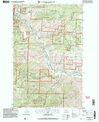
2003 Map of Ardenvoir
USGS Topo · Published 2006About this map
Ardenvoir serves as the central hub of this topographical study, situated at the confluence of the Entiat River and the Mad River. The landscape is defined by the steep transitions of the Entiat Valley, where irrigation infrastructure like the Hanan Ditch supports local activity amidst the surrounding Wenatchee National Forest. This era of land management is reflected in the dual presence of the Entiat State Wildlife Area and various resource-focused sites, including a Fish Hatchery and numerous prospects and adits indicating a history of mineral exploration.
Find a feature on this map
43 named features on this map. Tap any name to fly to it.
Don’t see what you’re looking for? This feature index may not catch every label — zoom into the map to look around manually.
Map Details
Editions of this 2003 Ardenvoir Map
This is the sole edition of this map. No revisions or reprints were ever made.
Other maps of this area

1901 · Chelan
USGS Topo · 1:125,000

1957 · Wenatchee
USGS Topo · 1:250,000

1968 · Orondo
USGS Topo · 1:24,000

1968 · Entiat
USGS Topo · 1:24,000
1968 · Cashmere
USGS Topo · 1:24,000

1968 · Tyee Mtn.
USGS Topo · 1:24,000

1968 · Ardenvoir
USGS Topo · 1:24,000

1968 · Baldy Mtn
USGS Topo · 1:24,000
1968 · Chumstick Mtn
USGS Topo · 1:24,000

1968 · Winesap
USGS Topo · 1:24,000