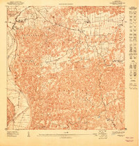
1947 Map of Arecibo SE
USGS Topo · Published 1947About this map
The Rio Grande de Arecibo winds along the western edge of this 1940s topographic study, defining the boundary for the densely contoured terrain of the Arenalejos and Carreras districts. This preliminary survey, prepared during the early 1940s, illustrates a landscape transition from the river valley into the complex limestone karst formations typical of northern Puerto Rico. Small clusters of rural settlement like Bajadero and Domingo Ruiz are documented alongside vital social infrastructure, most notably the Escuela Segunda Unidad de Bajadero, which served as a central educational hub for the surrounding barrios.
Find a feature on this map
18 named features on this map. Tap any name to fly to it.
Don’t see what you’re looking for? This feature index may not catch every label — zoom into the map to look around manually.
Map Details
Editions of this 1947 Arecibo SE Map
This is the sole edition of this map. No revisions or reprints were ever made.
Other maps of this area

1942 · Arecibo
USGS Topo · 1:30,000

1942 · Barceloneta
USGS Topo · 1:30,000

1943 · Utuado NE
USGS Topo · 1:10,000

1946 · Barceloneta
USGS Topo · 1:30,000

1946 · Utuado
USGS Topo · 1:30,000

1946 · Arecibo
USGS Topo · 1:30,000

1946 · Florida
USGS Topo · 1:30,000
1947 · Barceloneta SO
USGS Topo · 1:10,000
1947 · Florida NO
USGS Topo · 1:10,000
1947 · Arecibo SO
USGS Topo · 1:10,000