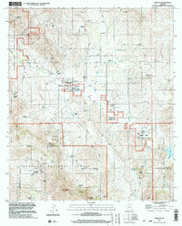
1996 Map of Arivaca
USGS Topo · Published 2002About this map
Arivaca serves as the central hub of this Southern Arizona landscape, where the high desert terrain of the Las Guijas Mountains meets the southern Cobre Ridge. The settlement is defined by a ranching and mining economy, evidenced by historical sites such as the Arivaca Ranch and a local Cem (cemetery). Evidence of the area's prospecting history is scattered throughout the canyons, including the Ajax Mine, Alaska Mine, and Edwards Mine.
Find a feature on this map
55 named features on this map. Tap any name to fly to it.
Don’t see what you’re looking for? This feature index may not catch every label — zoom into the map to look around manually.
Map Details
Editions of this 1996 Arivaca Map
This is the sole edition of this map. No revisions or reprints were ever made.
Other maps of this area

1920 · Arivaca
USGS Topo · 1:125,000

1921 · Old Glory
USGS Topo · 1:125,000

1939 · Tubac
USGS Topo · 1:62,500

1941 · Arivaca
USGS Topo · 1:62,500

1942 · Ruby
USGS Topo · 1:62,500

1942 · Oro Blanco
USGS Topo · 1:62,500

1943 · Arivaca
USGS Topo · 1:62,500

1943 · Old Glory
USGS Topo · 1:125,000

1943 · Tubac
USGS Topo · 1:62,500

1944 · Oro Blanco
USGS Topo · 1:62,500