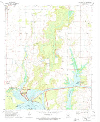
1972 Map of Arkansas Post
USGS Topo · Published 1974About this map
The Arkansas Post National Memorial stands as a focal point at the confluence of the Arkansas River and Little Post Bayou, marking the site of one of the earliest European settlements in the Lower Mississippi Valley. By the early 1970s, the landscape surrounding this historic ground was a complex network of wetlands and modern water management features, including the Arkansas Post Canal and Lake Merrisach. The presence of several family and community burial grounds, such as Champion Cem, Hinmon Cem, and Massey Cem, underscores the deep genealogical roots in this rural Arkansas region. North of the memorial, the sprawling Dismal Swamp contrasts with the agricultural layout near Gillett, illustrating the balance between the area's wild bottomlands and its developed farming communities during this era.
Find a feature on this map
34 named features on this map. Tap any name to fly to it.
Don’t see what you’re looking for? This feature index may not catch every label — zoom into the map to look around manually.
Map Details
Editions of this 1972 Arkansas Post Map
This is the sole edition of this map. No revisions or reprints were ever made.
Other maps of this area

1935 · Red Fork
USGS Topo · 1:62,500

1935 · Gillett
USGS Topo · 1:62,500

1939 · Henrico
USGS Topo · 1:62,500

1939 · Big Island
USGS Topo · 1:62,500

1948 · Helena
USGS Topo · 1:250,000

1950 · Helena
USGS Topo · 1:250,000

1953 · Greenwood
USGS Topo · 1:250,000

1954 · Henrico
USGS Topo · 1:62,500

1955 · Helena
USGS Topo · 1:250,000

1956 · Greenwood
USGS Topo · 1:250,000