
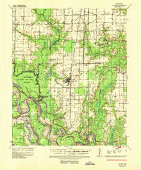
1935 Map of Gillett
USGS Topo · Published 1945About this map
Gillett serves as the central hub of this agricultural landscape in the mid-1930s, situated at the junction of the St Louis Southwestern railroad and State Highway No 1. The map reveals a complex system of water management essential for local cultivation, featuring the Rice Flume and numerous drainage structures like Ditch Co Rd 5. To the south, the Arkansas River dictates the terrain with dramatic meanders and historical markers, including the Meander Line 1819 and the Cooks Point Cut-Off.
Find a feature on this map
73 named features on this map. Tap any name to fly to it.
Don’t see what you’re looking for? This feature index may not catch every label — zoom into the map to look around manually.
Map Details
Editions of this 1935 Gillett Map
2 editions found
Other maps of this area

1935 · Varner
USGS Topo · 1:62,500

1935 · Rotan
USGS Topo · 1:62,500

1935 · Red Fork
USGS Topo · 1:62,500

1939 · Indian Bay
USGS Topo · 1:62,500

1939 · Henrico
USGS Topo · 1:62,500

1939 · Big Island
USGS Topo · 1:62,500

1941 · De Witt
USGS Topo · 1:62,500

1941 · Goldman
USGS Topo · 1:62,500

1948 · Helena
USGS Topo · 1:250,000

1950 · Helena
USGS Topo · 1:250,000