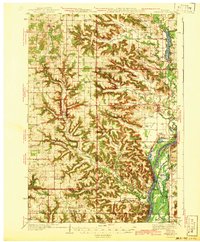
1942 Map of Arkansaw
USGS Topo · Published 1942About this map
Arkansaw sits at the heart of this landscape where the Eau Galle River winds toward its confluence with the Chippewa River. The terrain is defined by an intricate network of ridges and coulees, including named landmarks like The Hogback and The Notch. This 1942 edition, compiled from surveys by J.C. Hilliard and aerial photography by the Air Corps U.S. Army, captures the region's rural character during a period of established agricultural settlement.
Find a feature on this map
85 named features on this map. Tap any name to fly to it.
Don’t see what you’re looking for? This feature index may not catch every label — zoom into the map to look around manually.
Map Details
Editions of this 1942 Arkansaw Map
2 editions found
Other maps of this area

1929 · Durand
USGS Topo · 1:62,500

1932 · Wabasha
USGS Topo · 1:62,500

1932 · Durand
USGS Topo · 1:62,500

1932 · Alma
USGS Topo · 1:62,500

1935 · Arkansaw
USGS Topo · 1:48,000

1940 · Maiden Rock
USGS Topo · 1:62,500

1940 · Menomonie
USGS Topo · 1:62,500

1941 · Arkansaw
USGS Topo · 1:62,500

1942 · Arkansaw
USGS Topo · 1:62,500

1942 · Menomonie
USGS Topo · 1:62,500