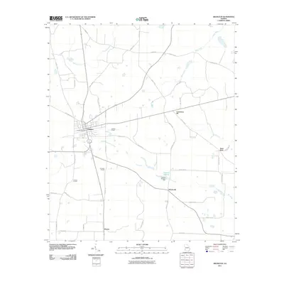
2011 Map of Arlington
USGS Topo · Published 2011About this map
The town of Arlington serves as the central hub of this agricultural landscape in Southwest Georgia, where long-established road networks connect dispersed rural communities. The map highlights the intersection of local commerce and transit, centered on the Arlington Post Office and nearby small-scale aviation facilities like Jordans Airport and Andrews Airport. Beyond the main settlement, the terrain is defined by its water systems and early industry, including the Sheffield Millpond and its associated Sheffield Millpond Dam along Mill Creek. Smaller outlying locales such as Nicholasville, Rowena, and Jones Spur indicate the historical footprint of early 21st-century rural life. Family and community heritage is anchored by landmarks like Timmons Cemetery and Commissary Hill, while a network of drainage ways including Tennelle Creek and Boggy Creek shape the surrounding farmland.
Find a feature on this map
49 named features on this map. Tap any name to fly to it.
Don’t see what you’re looking for? This feature index may not catch every label — zoom into the map to look around manually.
Map Details
Editions of this 2011 Arlington Map
This is the sole edition of this map. No revisions or reprints were ever made.
Other maps of this area

1953 · Dothan
USGS Topo · 1:250,000

1954 · Dothan
USGS Topo · 1:250,000

1955 · Dothan
USGS Topo · 1:250,000

1973 · Morgan
USGS Topo · 1:24,000

1973 · Bancroft
USGS Topo · 1:24,000

1973 · Edison
USGS Topo · 1:24,000
1973 · Bluffton
USGS Topo · 1:24,000

1973 · Hentown
USGS Topo · 1:24,000

1974 · Damascus
USGS Topo · 1:24,000

1974 · Arlington
USGS Topo · 1:24,000