
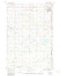
1968 Map of Arlington
USGS Topo · Published 1970About this map
The prairie landscape of eastern Kingsbury County is defined here by a network of glacial lakes and the crossing of two major rail lines. Arlington sits at the junction of the Great Northern and Chicago and North Western railroads, serving as a hub for the surrounding agricultural townships of Denver and Spring Lake. The terrain is dotted with significant water bodies including the expansive Lake Whitewood and the Twin Lakes to the east, while the Tenneboe Slough cuts through the central sections.
Find a feature on this map
22 named features on this map. Tap any name to fly to it.
Don’t see what you’re looking for? This feature index may not catch every label — zoom into the map to look around manually.
Map Details
Editions of this 1968 Arlington Map
2 editions found
Other maps of this area

1953 · Watertown
USGS Topo · 1:250,000

1958 · Watertown
USGS Topo · 1:250,000

1968 · Lake Sinai
USGS Topo · 1:24,000

1968 · Lake Preston East
USGS Topo · 1:24,000

1968 · Lake Preston NE
USGS Topo · 1:24,000

1968 · Arlington NE
USGS Topo · 1:24,000

1968 · Sinai
USGS Topo · 1:24,000

1968 · Oldham
USGS Topo · 1:24,000

1968 · Badger
USGS Topo · 1:24,000
1968 · Madison NW
USGS Topo · 1:24,000