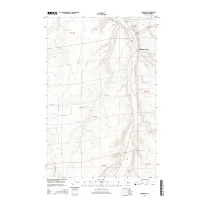
2014 Map of Armington
USGS Topo · Published 2014About this map
Armington and the nearby Armington Junction serve as the primary focal points of this 2014 survey in Cascade County, where the plains of Central Montana meet the distinct topography of the Little Belt Mountains' foothills. The landscape is defined by the winding course of Belt Creek, which is joined by Big Otter Creek and Armington Coulee near the town sites. To the west, the elevated terrain of Swede Bench and French Coulee reflects the area's agricultural and ranching heritage, bisected by a network of rural routes including Tiger Butte Rd and Neel Creek Rd. Local history is anchored at Pleasant View Cem and Goodman Cem, while the junction of Us-87 and Us-89 highlights the region's role as a transportation corridor connecting Great Falls with the Judith Basin.
Find a feature on this map
31 named features on this map. Tap any name to fly to it.
Don’t see what you’re looking for? This feature index may not catch every label — zoom into the map to look around manually.
Map Details
Editions of this 2014 Armington Map
This is the sole edition of this map. No revisions or reprints were ever made.
Other maps of this area

1886 · Great Falls
USGS Topo · 1:250,000

1890 · Fort Benton
USGS Topo · 1:250,000

1892 · Fort Benton
USGS Topo · 1:250,000

1897 · Fort Benton
USGS Topo · 1:250,000

1954 · Great Falls
USGS Topo · 1:250,000

1955 · Stockett
USGS Topo · 1:62,500

1956 · Belt
USGS Topo · 1:62,500

1957 · Great Falls
USGS Topo · 1:250,000
1965 · Fife
USGS Topo · 1:24,000

1965 · Mahoney Hill
USGS Topo · 1:24,000