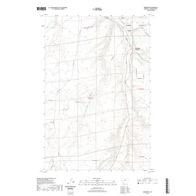
2020 Map of Armington
USGS Topo · Published 2020About this map
Armington and Armington Junction sit at the northern edge of this high plains landscape, where the confluence of Belt Creek and Big Otter Creek creates a natural corridor through the surrounding breaks. This 2020 survey illustrates a region defined by its topography and transit, where modern roads like the Armington Rd follow the drainage of Armington Coulee. The terrain transitions from the flat expanse of Swede Bench in the west to the higher elevations of Rainbow Ridge and the Little Belt Way in the east. Local history is anchored by the Pleasant View Cem and Goodman Cem, while the extensive network of rural routes including Tiger Butte Rd and Neel Creek Rd connects isolated ranchlands. Drainage systems such as Box Elder Cr and French Coulee carve the landscape, shaping the development of this Cascade County community.
Find a feature on this map
29 named features on this map. Tap any name to fly to it.
Don’t see what you’re looking for? This feature index may not catch every label — zoom into the map to look around manually.
Map Details
Editions of this 2020 Armington Map
This is the sole edition of this map. No revisions or reprints were ever made.
Other maps of this area

1886 · Great Falls
USGS Topo · 1:250,000

1890 · Fort Benton
USGS Topo · 1:250,000

1892 · Fort Benton
USGS Topo · 1:250,000

1897 · Fort Benton
USGS Topo · 1:250,000

1954 · Great Falls
USGS Topo · 1:250,000

1955 · Stockett
USGS Topo · 1:62,500

1956 · Belt
USGS Topo · 1:62,500

1957 · Great Falls
USGS Topo · 1:250,000
1965 · Fife
USGS Topo · 1:24,000

1965 · Mahoney Hill
USGS Topo · 1:24,000