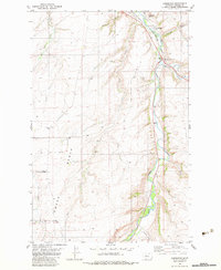
1982 Map of Armington
USGS Topo · Published 1983About this map
Belt Creek carves a deep valley through this portion of Cascade County, creating a sharp contrast between the irrigated bottomlands and the high, windswept terrain of Swede Bench. In the early 1980s, the small community of Armington and its neighbor Armington Junction serve as the primary hubs for this agricultural and transport corridor. The Burlington Northern railroad follows the winding path of the creek, a lifeline for moving grain and minerals from the nearby plains. Cultural landmarks like the Tiger Butte Community Center and Pleasant View Cemetery provide a sense of the long-standing community ties in this rural landscape. Along the hillsides, signs of industry appear in the form of several Gravel Pits, while the Neil Creek Ranch represents the ranching heritage that persists alongside the watercourses of Big Otter Creek and French Coulee.
Find a feature on this map
16 named features on this map. Tap any name to fly to it.
Don’t see what you’re looking for? This feature index may not catch every label — zoom into the map to look around manually.
Map Details
Editions of this 1982 Armington Map
This is the sole edition of this map. No revisions or reprints were ever made.
Other maps of this area

1886 · Great Falls
USGS Topo · 1:250,000

1890 · Fort Benton
USGS Topo · 1:250,000

1892 · Fort Benton
USGS Topo · 1:250,000

1897 · Fort Benton
USGS Topo · 1:250,000

1954 · Great Falls
USGS Topo · 1:250,000

1955 · Stockett
USGS Topo · 1:62,500

1956 · Belt
USGS Topo · 1:62,500

1957 · Great Falls
USGS Topo · 1:250,000
1965 · Fife
USGS Topo · 1:24,000

1965 · Mahoney Hill
USGS Topo · 1:24,000