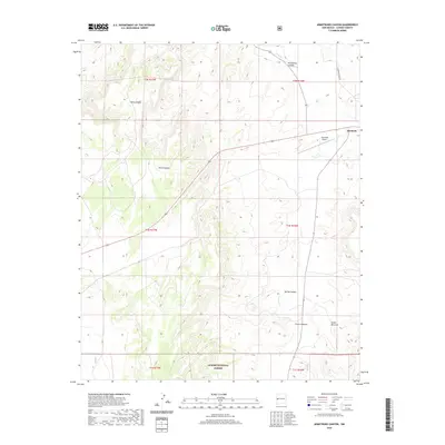
2020 Map of Armstrong Canyon
USGS Topo · Published 2020About this map
Quemado sits at the edge of a landscape defined by deep drainages and high mesas, where the high desert meets the northern reaches of the Apache National Forest. This area of Catron County is characterized by a series of significant erosional features, including Armstrong Canyon, Dark Canyon, and Amen Canyon, which channel seasonal water toward the wider valley of Largo Cr. The presence of the Quemado Airport and routes like Catron Co Rd A028 indicate the vital transportation links required for this western New Mexico ranching and forest community. Toward the south, the topography grows more complex near Spring Canyon and French Canyon, eventually transitioning into the rugged terrain of Cañon del Leon. The map illustrates a contemporary pattern of land use where small-scale aviation and remote forest access roads coexist with the traditional drainage systems of Rito Cr.
Find a feature on this map
18 named features on this map. Tap any name to fly to it.
Don’t see what you’re looking for? This feature index may not catch every label — zoom into the map to look around manually.
Map Details
Editions of this 2020 Armstrong Canyon Map
This is the sole edition of this map. No revisions or reprints were ever made.
Other maps of this area

1954 · Saint Johns
USGS Topo · 1:250,000

1957 · Saint Johns
USGS Topo · 1:250,000

1958 · Saint Johns
USGS Topo · 1:250,000

1962 · Saint Johns
USGS Topo · 1:250,000

1967 · Mariano Springs
USGS Topo · 1:24,000

1967 · Quemado
USGS Topo · 1:24,000

1972 · Lake Armijo
USGS Topo · 1:24,000

1972 · Tejana Mesa
USGS Topo · 1:24,000
1972 · Armstrong Canyon
USGS Topo · 1:24,000
1981 · Ponderosa Tank
USGS Topo · 1:24,000