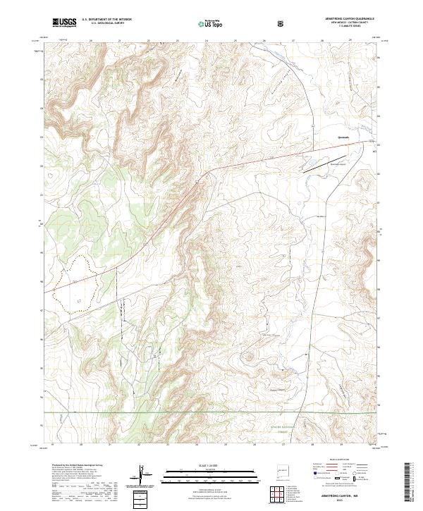
2023 Map of Armstrong Canyon
USGS Topo · Published 2023About this map
Quemado anchors this corner of Catron County, serving as a hub for the surrounding ranching and forest lands during the early 2020s. The landscape is defined by the winding course of Largo Creek, which cuts through high-elevation terrain punctuated by deep drainage systems. To the south, the protected boundaries of the Apache National Forest begin, indicating a transition into heavily timbered and federally managed wilderness. The transportation network is sparse, centered on the Quemado Airport and local thoroughfares like Catron Co Rd A028. Numerous canyons, including French Canyon, Spring Canyon, and the namesake Armstrong Canyon, reveal a complex topography of ridges and draws. Smaller watercourses like Rito Creek and Cañon del Leon illustrate the vital drainage patterns that shape the high desert environment.
Find a feature on this map
18 named features on this map. Tap any name to fly to it.
Don’t see what you’re looking for? This feature index may not catch every label — zoom into the map to look around manually.
Map Details
Editions of this 2023 Armstrong Canyon Map
This is the sole edition of this map. No revisions or reprints were ever made.
Other maps of this area

1954 · Saint Johns
USGS Topo · 1:250,000

1957 · Saint Johns
USGS Topo · 1:250,000

1958 · Saint Johns
USGS Topo · 1:250,000

1962 · Saint Johns
USGS Topo · 1:250,000

1967 · Mariano Springs
USGS Topo · 1:24,000

1967 · Quemado
USGS Topo · 1:24,000

1972 · Lake Armijo
USGS Topo · 1:24,000

1972 · Tejana Mesa
USGS Topo · 1:24,000
1972 · Armstrong Canyon
USGS Topo · 1:24,000
1981 · Ponderosa Tank
USGS Topo · 1:24,000