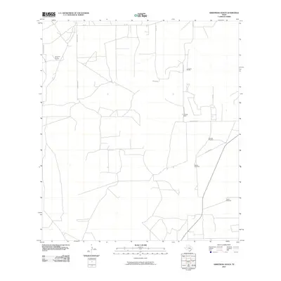
2010 Map of Armstrong Ranch
USGS Topo · Published 2010About this map
Armstrong Ranch serves as the focal point for this section of South Texas, where the landscape is defined by the resource-heavy industry of the coastal plains. The presence of the Las Animas Oil and Gas Field and the Armstrong Oil Field illustrates the economic importance of mineral extraction in this region. This industrial footprint is interspersed with essential ranching infrastructure, such as the Chorrito Windmill, Azucar Windmill, and Nuevo Windmill, which highlight the vital role of water management in an arid environment. A grid of rural roads, including Polo Creamer Ln and Aa Martinez Rd, connects these remote work sites and family-run operations. The layout of S Old Hwy 16 and Armstrong Rd reveals how transportation networks adapted to serve both the ranching community and the oil fields, providing a clear view of the regional land use at the end of the first decade of the millennium.
Find a feature on this map
14 named features on this map. Tap any name to fly to it.
Don’t see what you’re looking for? This feature index may not catch every label — zoom into the map to look around manually.
Map Details
Editions of this 2010 Armstrong Ranch Map
This is the sole edition of this map. No revisions or reprints were ever made.
Other maps of this area

1939 · Bruni
USGS Topo · 1:62,500

1939 · Randado
USGS Topo · 1:62,500

1940 · Randado
USGS Topo · 1:62,500

1956 · Laredo
USGS Topo · 1:250,000

1967 · Hebbronville
USGS Topo · 1:24,000

1972 · Armstrong Ranch
USGS Topo · 1:24,000
1972 · San Pablo Ranch
USGS Topo · 1:24,000

1972 · Albercas Ranch
USGS Topo · 1:24,000

1972 · Bruni SE
USGS Topo · 1:24,000
1972 · Alta Vista Ranch SW
USGS Topo · 1:24,000