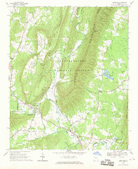
1968 Map of Armuchee
USGS Topo · Published 1970About this map
Johns Mountain and Sand Mountain dominate this corner of northwest Georgia, framing the tight agricultural corridors of Little Haywood Valley and the basin of Armuchee Creek. The landscape of the late 1960s shows a mix of public land within the Chattahoochee National Forest and established rural communities like Farmersville and Crystal Springs. A significant network of country churches and cemeteries, such as Bethel Ch and the Anderson Cem, anchors the valley floors, while specialized land uses like the Fish Hatchery near Arrowhead Lake point to the region's managed natural resources.
Find a feature on this map
50 named features on this map. Tap any name to fly to it.
Don’t see what you’re looking for? This feature index may not catch every label — zoom into the map to look around manually.
Map Details
Editions of this 1968 Armuchee Map
This is the sole edition of this map. No revisions or reprints were ever made.
Other maps of this area

1886 · Ringgold
USGS Topo · 1:125,000

1886 · Rome
USGS Topo · 1:125,000

1892 · Ringgold
USGS Topo · 1:125,000

1898 · Rome
USGS Topo · 1:125,000

1899 · Rome
USGS Topo · 1:125,000

1904 · Rome
USGS Topo · 1:125,000

1955 · Rome
USGS Topo · 1:250,000

1958 · Rome
USGS Topo · 1:250,000

1961 · Rome
USGS Topo · 1:250,000

1963 · Rome
USGS Topo · 1:250,000