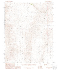
1986 Map of Arrow Canyon
USGS Topo · Published 1986About this map
Moapa River Indian Reservation lands occupy the southeastern corner of this arid Clark County landscape, where the terrain is defined by the high elevations of the Arrow Canyon Range. This mid-1980s provisional survey documents a network of primitive transportation routes, primarily labeled as 4wd tracks, which navigate through complex drainage systems like Pahranagat Wash and Arrow Canyon Wash. These washes represent the primary hydrological features in an otherwise dry environment, carved between significant landforms such as Hidden Canyon and Side Canyon. A notable landmark, Battleship, stands out among the unnamed peaks, while a single Prospect in the southwest suggests early mineral exploration. The map serves as a detailed record of the region's topography before significant modern development, showing the intersection of tribal land boundaries with the surrounding public domain.
Find a feature on this map
9 named features on this map. Tap any name to fly to it.
Don’t see what you’re looking for? This feature index may not catch every label — zoom into the map to look around manually.
Map Details
Editions of this 1986 Arrow Canyon Map
This is the sole edition of this map. No revisions or reprints were ever made.
Other maps of this area

1886 · Saint Thomas
USGS Topo · 1:250,000

1893 · Saint Thomas
USGS Topo · 1:250,000

1954 · Las Vegas
USGS Topo · 1:250,000

1957 · Las Vegas
USGS Topo · 1:250,000

1958 · Arrow Canyon
USGS Topo · 1:62,500

1958 · Moapa
USGS Topo · 1:62,500

1959 · Las Vegas
USGS Topo · 1:250,000

1962 · Las Vegas
USGS Topo · 1:250,000

1969 · Farrier
USGS Topo · 1:24,000
1969 · Wildcat Wash SE
USGS Topo · 1:24,000