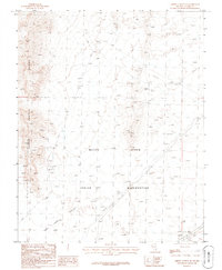
1986 Map of Arrow Canyon SE
USGS Topo · Published 1986About this map
The Moapa River Indian Reservation occupies a significant portion of this arid Nevada landscape, which is defined by the steep terrain of the Arrow Canyon Range. Industrial activity is evident throughout the area, notably at the Rock Quarry and a nearby Quarry, along with several points marked as Prospect. Infrastructure in the mid-1980s was anchored by the Union Pacific railroad corridor, which skirts the southeastern edge near the small settlement of Crystal. This railroad, alongside various utility lines marked as Trans Line, illustrates the region's role as a vital transportation and energy conduit between more populated basins. The vast desert floor of Dry Lake Valley stretches across the southern portion of the map, providing a stark contrast to the craggy peaks and technical landmarks like the isolated Radio Facility and surveying points Ute and Giant.
Find a feature on this map
12 named features on this map. Tap any name to fly to it.
Don’t see what you’re looking for? This feature index may not catch every label — zoom into the map to look around manually.
Map Details
Editions of this 1986 Arrow Canyon SE Map
This is the sole edition of this map. No revisions or reprints were ever made.
Other maps of this area

1886 · Saint Thomas
USGS Topo · 1:250,000

1893 · Saint Thomas
USGS Topo · 1:250,000

1926 · Boulder Canyon
USGS Topo · 1:96,000

1952 · Dry Lake
USGS Topo · 1:62,500

1953 · Muddy Peak
USGS Topo · 1:62,500

1954 · Las Vegas
USGS Topo · 1:250,000

1957 · Las Vegas
USGS Topo · 1:250,000

1958 · Arrow Canyon
USGS Topo · 1:62,500

1958 · Moapa
USGS Topo · 1:62,500

1959 · Las Vegas
USGS Topo · 1:250,000