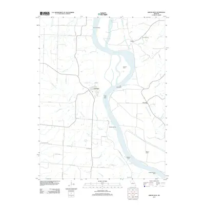
2012 Map of Arrow Rock
USGS Topo · Published 2012About this map
Arrow Rock and the surrounding river bottomlands are defined by the meandering path of the Missouri River in this 2012 study. The landscape is a complex network of active and former watercourses, including the Old Channel Salt Creek and numerous bends like Saline City Bend and Slough Creek. These waterways have historically dictated the placement of settlements such as Lisbon and Petersburg, which sit near the river's edge. This modern survey reflects the enduring geography of Saline County, where large features like Jameson Island and Wallace Island segment the river's flow. For genealogists, the map identifies several local burial sites, including Rose Hill Cemetery near Lisbon and Townsend Cemetery to the southwest, providing specific coordinates for family research. The abundance of named branches and springs, such as Brockway Spring and Boones Branch, highlights the importance of freshwater sources in the development of these riverfront communities.
Find a feature on this map
61 named features on this map. Tap any name to fly to it.
Don’t see what you’re looking for? This feature index may not catch every label — zoom into the map to look around manually.
Map Details
Editions of this 2012 Arrow Rock Map
This is the sole edition of this map. No revisions or reprints were ever made.
Other maps of this area

1887 · Sedalia
USGS Topo · 1:125,000

1888 · Boonville
USGS Topo · 1:125,000

1890 · Glasgow
USGS Topo · 1:125,000

1890 · Marshall
USGS Topo · 1:125,000

1892 · Marshall
USGS Topo · 1:125,000

1894 · Sedalia
USGS Topo · 1:125,000

1901 · Marshall
USGS Topo · 1:125,000

1940 · Marshall
USGS Topo · 1:62,500

1944 · Marshall
USGS Topo · 1:62,500

1947 · Glasgow
USGS Topo · 1:62,500