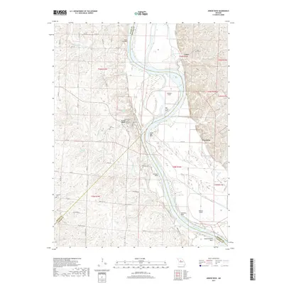
2017 Map of Arrow Rock
USGS Topo · Published 2017About this map
Arrow Rock stands as a significant cultural anchor on this modern survey, marking the intersection of the Missouri River and the historic Lewis and Clark Trail of Discovery. This portion of the river valley is defined by dramatic meanders including Saline City Bend, Arrow Rock Bend, and Robinson Bends, which shape the low-lying terrain around Jameson Island and Wallace Island. The map meticulously documents the rural landscape across the borders of Saline, Howard, and Cooper Counties, revealing a network of agricultural roads and several cemeteries including Arrow Rock Cem and Rose Hill Cem. The presence of Brockway Spring and numerous tributaries like Pierre Fleche Cr and Slough Cr underscore the complex hydrology of this riverine environment. Beyond the main settlement of Arrow Rock, the map identifies the locations of Lisbon and Petersburg, providing a detailed view of the regional geography as it appeared in the late 2010s.
Find a feature on this map
67 named features on this map. Tap any name to fly to it.
Don’t see what you’re looking for? This feature index may not catch every label — zoom into the map to look around manually.
Map Details
Editions of this 2017 Arrow Rock Map
This is the sole edition of this map. No revisions or reprints were ever made.
Other maps of this area

1887 · Sedalia
USGS Topo · 1:125,000

1888 · Boonville
USGS Topo · 1:125,000

1890 · Glasgow
USGS Topo · 1:125,000

1890 · Marshall
USGS Topo · 1:125,000

1892 · Marshall
USGS Topo · 1:125,000

1894 · Sedalia
USGS Topo · 1:125,000

1901 · Marshall
USGS Topo · 1:125,000

1940 · Marshall
USGS Topo · 1:62,500

1944 · Marshall
USGS Topo · 1:62,500

1947 · Glasgow
USGS Topo · 1:62,500