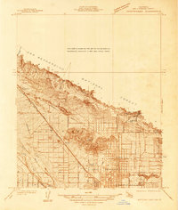
1936 Map of Arrowhead
USGS Topo · Published 1936About this map
The northern reaches of San Bernardino meet the foothills of the San Bernardino National Forest in this 1930s survey. The landscape is defined by the sharp transition from the steep, carved terrain of Devil Canyon to the alluvial flats where Lytle Creek Wash and Cajon Creek converge. This period captures the city's early 20th-century expansion, shown through an organized grid of streets such as Highland Ave and Waterman Ave pushing toward the mountain base.
Find a feature on this map
36 named features on this map. Tap any name to fly to it.
Don’t see what you’re looking for? This feature index may not catch every label — zoom into the map to look around manually.
Map Details
Editions of this 1936 Arrowhead Map
This is the sole edition of this map. No revisions or reprints were ever made.
Other maps of this area

1896 · San Bernardino
USGS Topo · 1:62,500

1898 · San Bernardino
USGS Topo · 1:62,500

1899 · Redlands
USGS Topo · 1:62,500

1901 · Southern California Sheet No. 1
USGS Topo · 1:250,000

1901 · San Bernardino
USGS Topo · 1:62,500

1901 · Redlands
USGS Topo · 1:62,500

1902 · Deep Creek
USGS Topo · 1:62,500

1902 · Hesperia
USGS Topo · 1:62,500

1904 · Southern California Sheet No. 1
USGS Topo · 1:250,000
1936 · Devore
USGS Topo · 1:31,680