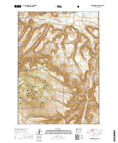
2020 Map of Arrowwood Point
USGS Topo · Published 2020About this map
Ochoco National Forest dominates the southern half of this landscape, where high-desert terrain rises toward the prominent landmark of Arrowwood Point. The northern portion is defined by the winding course of the Crooked River and its confluence with the North Fork Crooked River, a region managed for water resources as evidenced by the series of catchments including Mainline Reservoir Number 1, Number 2, and Number 3. The geography suggests a working landscape of timber and ranching, intersected by local routes like SE Paulina Hwy and Maury Rd. For local historians and genealogists, the Maury Mountain Cem sits near the base of Maury Mountain, providing a specific point of interest in an otherwise sparsely populated area. The presence of numerous seasonal drainages such as Cemetery Cr, Poison Cr, and Camp Cr illustrates the complex hydrology of this part of Crook County.
Find a feature on this map
23 named features on this map. Tap any name to fly to it.
Don’t see what you’re looking for? This feature index may not catch every label — zoom into the map to look around manually.
Map Details
Editions of this 2020 Arrowwood Point Map
This is the sole edition of this map. No revisions or reprints were ever made.
Other maps of this area

1951 · Post
USGS Topo · 1:62,500

1955 · Crescent
USGS Topo · 1:250,000

1955 · Bend
USGS Topo · 1:250,000

1957 · Crescent
USGS Topo · 1:250,000

1957 · Bend
USGS Topo · 1:250,000

1958 · Crescent
USGS Topo · 1:250,000

1958 · Bend
USGS Topo · 1:250,000

1970 · Crescent
USGS Topo · 1:250,000

1981 · Prineville
USGS Topo · 1:100,000

1982 · Arrowwood Point
USGS Topo · 1:24,000