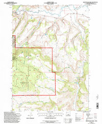
1992 Map of Arrowwood Point
USGS Topo · Published 1997About this map
The Maury Mountains dominate this central Oregon landscape within the Ochoco National Forest, where the high-altitude terrain is defined by complex drainage systems and isolated peaks. Water management is a primary feature of the high desert ranching and forest service economy, evidenced by several water storage sites such as Poison Creek Reservoir, George Reservoir, and Severance Reservoir. The northern boundary is marked by the winding path of the Crooked River, which provides a stark contrast to the drier southern ridges.
Find a feature on this map
46 named features on this map. Tap any name to fly to it.
Don’t see what you’re looking for? This feature index may not catch every label — zoom into the map to look around manually.
Map Details
Editions of this 1992 Arrowwood Point Map
This is the sole edition of this map. No revisions or reprints were ever made.
Other maps of this area

1951 · Post
USGS Topo · 1:62,500

1955 · Crescent
USGS Topo · 1:250,000

1955 · Bend
USGS Topo · 1:250,000

1957 · Crescent
USGS Topo · 1:250,000

1957 · Bend
USGS Topo · 1:250,000

1958 · Crescent
USGS Topo · 1:250,000

1958 · Bend
USGS Topo · 1:250,000

1970 · Crescent
USGS Topo · 1:250,000

1981 · Prineville
USGS Topo · 1:100,000

1982 · Arrowwood Point
USGS Topo · 1:24,000