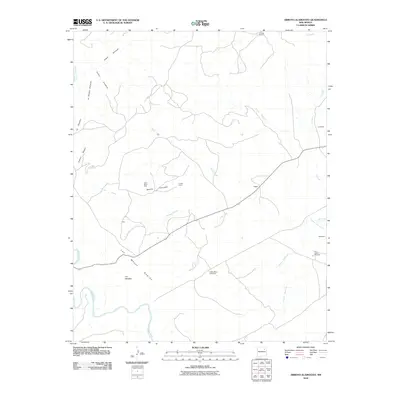
2010 Map of Arroyo Alamocito
USGS Topo · Published 2010About this map
The Canadian River cuts through this high-plains landscape in San Miguel County, anchoring a terrain defined by dramatic mesas and drainage arroyos. Ranching culture and land claims are prominent throughout the quadrangle, evidenced by the El Villa Claim and active locations such as La Cinta Ranch and Lujan Ranch West. The presence of Black Mesa Windmill and Sixty Gallon Windmill highlights the critical importance of water infrastructure in this arid environment, where life centers around reliable water sources and named drainage systems like Arroyo Alamocito and Arroyo Salitre. To the south, the massive Las Mesas Negras dominates the horizon, while smaller settlements and family sites including Lujan, Eggert, and Waggoner are scattered along the 419 corridor. The map preserves a network of canyons such as Cabra Canyon and Cañon Negro, illustrating the complex topography that historically dictated movement and settlement patterns in this part of New Mexico.
Find a feature on this map
25 named features on this map. Tap any name to fly to it.
Don’t see what you’re looking for? This feature index may not catch every label — zoom into the map to look around manually.
Map Details
Editions of this 2010 Arroyo Alamocito Map
This is the sole edition of this map. No revisions or reprints were ever made.
Other maps of this area

1954 · Santa Fe
USGS Topo · 1:250,000

1958 · Santa Fe
USGS Topo · 1:250,000

1971 · Alamito
USGS Topo · 1:24,000

1971 · Canon Encierro
USGS Topo · 1:24,000

1972 · Arroyo Alamocito
USGS Topo · 1:24,000

1972 · Montoya Point
USGS Topo · 1:24,000
1972 · San Ramon
USGS Topo · 1:24,000
1972 · Sabinoso
USGS Topo · 1:24,000

1972 · Wade Canyon
USGS Topo · 1:24,000
1972 · Minese Mesa
USGS Topo · 1:24,000