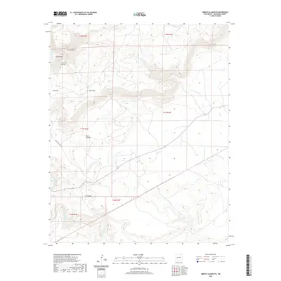
2020 Map of Arroyo Alamocito
USGS Topo · Published 2020About this map
The Canadian River cuts through the western edge of this San Miguel County landscape, defining a region of dramatic elevation changes and named drainage systems. The terrain is deeply incised by canyons and arroyos, with prominent landmarks such as Canon Cordova and Cabra Canyon in the northwest, while the center is dominated by the broad course of the Arroyo Alamocito. Several smaller tributaries, including Frank Cr, Ross Cr, and Arroyo Salitre, highlight the complex hydrologic network that feeds into the larger river basin.
Find a feature on this map
21 named features on this map. Tap any name to fly to it.
Don’t see what you’re looking for? This feature index may not catch every label — zoom into the map to look around manually.
Map Details
Editions of this 2020 Arroyo Alamocito Map
This is the sole edition of this map. No revisions or reprints were ever made.
Other maps of this area

1954 · Santa Fe
USGS Topo · 1:250,000

1958 · Santa Fe
USGS Topo · 1:250,000

1971 · Alamito
USGS Topo · 1:24,000

1971 · Canon Encierro
USGS Topo · 1:24,000

1972 · Arroyo Alamocito
USGS Topo · 1:24,000

1972 · Montoya Point
USGS Topo · 1:24,000
1972 · San Ramon
USGS Topo · 1:24,000
1972 · Sabinoso
USGS Topo · 1:24,000

1972 · Wade Canyon
USGS Topo · 1:24,000
1972 · Minese Mesa
USGS Topo · 1:24,000