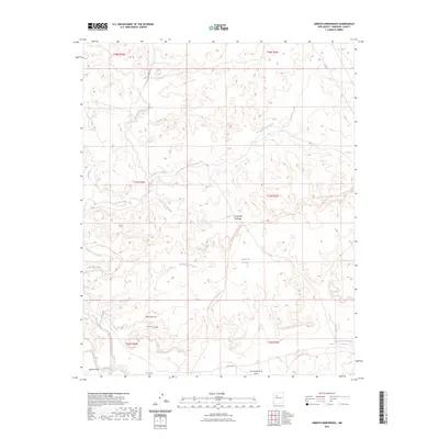
2023 Map of Arroyo Empedrado
USGS Topo · Published 2023About this map
Mesa San Luis and the vast Rincon Largo dominate this high-desert landscape in Sandoval County. The drainage network is intricately defined by deep-cut watercourses such as Torreon Wash, Arroyo Piedra Lumbre, and the namesake Arroyo Empedrado. Modern infrastructure meets legacy paths as the Continental Divide National Scenic Trl winds through the central terrain, crossing old corridors like the Wagon Trail Trl. Near the southern boundary, the Cabezon Community Reservoir serves as a critical water point in this arid environment, situated near the headwaters of Arroyo Chico. The map documents a landscape where land-use patterns are dictated by the natural erosive features of the cañadas and lagunas, including La Cañada Santiago and Laguna de la Leña.
Find a feature on this map
23 named features on this map. Tap any name to fly to it.
Don’t see what you’re looking for? This feature index may not catch every label — zoom into the map to look around manually.
Map Details
Editions of this 2023 Arroyo Empedrado Map
This is the sole edition of this map. No revisions or reprints were ever made.
Other maps of this area

1883 · Mt. Taylor
USGS Topo · 1:250,000

1886 · Mt. Taylor
USGS Topo · 1:250,000

1892 · Mt. Taylor
USGS Topo · 1:250,000

1899 · Mt. Taylor
USGS Topo · 1:250,000

1958 · Albuquerque
USGS Topo · 1:250,000
1961 · Headcut Reservoir
USGS Topo · 1:24,000

1961 · Cerro Parido
USGS Topo · 1:24,000

1961 · Arroyo Empedrado
USGS Topo · 1:24,000
1961 · Canada Calladita
USGS Topo · 1:24,000
1961 · Tinian
USGS Topo · 1:24,000