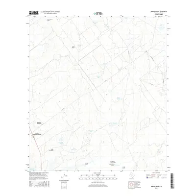
2016 Map of Arroyo Miguel
USGS Topo · Published 2016About this map
Morales-Sanchez Colonia stands as the primary residential hub in this arid reach of South Texas, positioned along FM 2687. The landscape is defined by an intricate network of ephemeral watercourses and livestock tanks, essential features for the ranching operations that characterize the region. Names like Esado Tank, Benevides Tank, and Margarita Tank suggest a long history of family-managed lands. To the south, the topography descends toward the margins of the Falcon Reservoir, where drainage systems like Arroyo Miguel and Arroyo Salado converge. This survey provides a clear look at the rural infrastructure of Zapata County, from the winding path of Huisache Ranch Rd to the isolated Charco Redondo Spring, illustrating the intersection of modern settlements and traditional land use in the Brush Country.
Find a feature on this map
31 named features on this map. Tap any name to fly to it.
Don’t see what you’re looking for? This feature index may not catch every label — zoom into the map to look around manually.
Map Details
Editions of this 2016 Arroyo Miguel Map
This is the sole edition of this map. No revisions or reprints were ever made.
Other maps of this area

1938 · Falcon
USGS Topo · 1:62,500

1938 · El Sauz
USGS Topo · 1:62,500

1938 · Cuevitas
USGS Topo · 1:62,500

1949 · Mc Allen
USGS Topo · 1:250,000

1954 · McAllen
USGS Topo · 1:250,000

1956 · Arroyo Clareno
USGS Topo · 1:62,500

1957 · Mc Allen
USGS Topo · 1:250,000

1962 · McAllen
USGS Topo · 1:250,000

1965 · Lopeno
USGS Topo · 1:24,000
1965 · Beckwith Arm
USGS Topo · 1:24,000