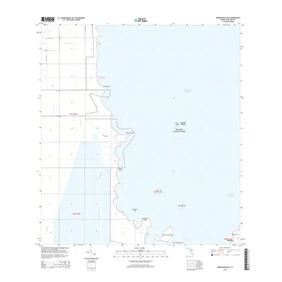
2015 Map of Arsenicker Keys
USGS Topo · Published 2015About this map
Biscayne National Park protects a vast expanse of marine and mangrove environments where the southern Florida mainland meets the Atlantic. This survey documents the complex intersection of man-made waterways and natural coastal features, including the Military Canal and Florida City Canal which cut through the low-lying terrain to reach the bay. The map shows the remote settlement of Islandia on the outer keys, a remnant of mid-century development dreams within the park boundaries. Navigation and conservation are the primary themes here, with the Intracoastal Waterway threading past islands such as West Arsenicker Key and Long Arsenicker Key. To the north, prominent coastal markers like Convoy Point and Turkey Point define the shoreline, while the offshore Sponge Rocks and Pelican Bank highlight the shallow marine geography characteristic of this subtropical ecosystem.
Find a feature on this map
31 named features on this map. Tap any name to fly to it.
Don’t see what you’re looking for? This feature index may not catch every label — zoom into the map to look around manually.
Map Details
Editions of this 2015 Arsenicker Keys Map
This is the sole edition of this map. No revisions or reprints were ever made.
Other maps of this area

1948 · Soldier Key
USGS Topo · 1:24,000

1949 · Elliott Key
USGS Topo · 1:24,000

1949 · Card Sound
USGS Topo · 1:24,000

1949 · Pacific Reef
USGS Topo · 1:24,000

1949 · Arsenicker Keys
USGS Topo · 1:24,000

1949 · Goulds
USGS Topo · 1:24,000

1949 · Perrine
USGS Topo · 1:24,000

1950 · Homestead
USGS Topo · 1:24,000

1950 · Glades
USGS Topo · 1:24,000

1956 · Goulds
USGS Topo · 1:24,000