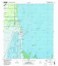
1997 Map of Arsenicker Keys
USGS Topo · Published 1998About this map
Biscayne National Park dominates this late-twentieth-century coastal landscape, where the edge of the Florida mainland meets the expansive waters of Biscayne Bay. The shoreline is defined by a complex intersection of industrial infrastructure and protected natural areas. Most striking is the extensive network of Cooling Canals associated with the Turkey Point Nuclear Power Plant, creating a geometric water pattern that contrasts sharply with the nearby mangrove coast. To the north, the presence of Homestead Air Force Base and the historic alignment of Kings Highway indicate the region's military and transport importance. Several canals, including the Mowry Canal and Florida City Canal, cut through the terrain toward the bay, while recreational spaces like Homestead Bayfront County Park offer access to the water. The southern portion of the sheet transitions into the bay's islands, featuring Arsenicker Key and West Arsenicker Key set amidst shallow flats and banks.
Find a feature on this map
34 named features on this map. Tap any name to fly to it.
Don’t see what you’re looking for? This feature index may not catch every label — zoom into the map to look around manually.
Map Details
Editions of this 1997 Arsenicker Keys Map
This is the sole edition of this map. No revisions or reprints were ever made.
Other maps of this area

1948 · Soldier Key
USGS Topo · 1:24,000

1949 · Elliott Key
USGS Topo · 1:24,000

1949 · Card Sound
USGS Topo · 1:24,000

1949 · Pacific Reef
USGS Topo · 1:24,000

1949 · Arsenicker Keys
USGS Topo · 1:24,000

1949 · Goulds
USGS Topo · 1:24,000

1949 · Perrine
USGS Topo · 1:24,000

1950 · Homestead
USGS Topo · 1:24,000

1950 · Glades
USGS Topo · 1:24,000

1956 · Goulds
USGS Topo · 1:24,000