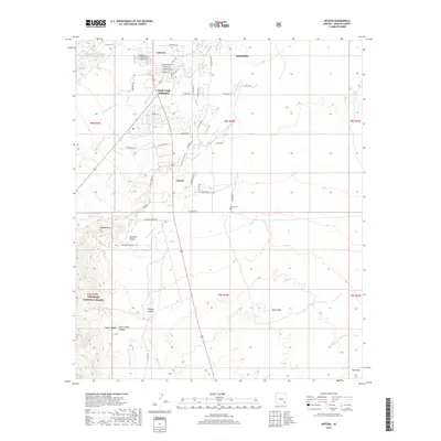
2018 Map of Artesia
USGS Topo · Published 2018About this map
Artesia and the surrounding desert landscape of Graham County appear here in detail, defined by a complex network of seasonal watercourses and local ranching roads. The settlement patterns are concentrated along the north-south corridor of Highway 191, where Swift Trail Junction and Lebanon serve as local hubs near the base of the mountains. To the west, the terrain rises sharply into the Coronado National Forest, marked by the prominent summit of Metate Peak and a series of rugged drainages including Lefthand Canyon and Dutch Henry Canyon. The drainage system is dominated by the expansive Marijilda Wash and Stockton Wash, which carry runoff across the arid valley floor. Local landmarks like the Artesia Cemetery and Lebanon Reservoir Number Two provide specific points of interest for genealogists and local historians tracking the development of these small Arizona communities.
Find a feature on this map
53 named features on this map. Tap any name to fly to it.
Don’t see what you’re looking for? This feature index may not catch every label — zoom into the map to look around manually.
Map Details
Editions of this 2018 Artesia Map
This is the sole edition of this map. No revisions or reprints were ever made.
Other maps of this area

1942 · Mt. Graham
USGS Topo · 1:62,500

1945 · Mt. Graham
USGS Topo · 1:62,500

1954 · Silver City
USGS Topo · 1:250,000

1958 · Silver City
USGS Topo · 1:250,000

1960 · Thatcher
USGS Topo · 1:62,500

1960 · Safford
USGS Topo · 1:62,500

1962 · Silver City
USGS Topo · 1:250,000
1966 · Tanque
USGS Topo · 1:24,000
1966 · Artesia NE
USGS Topo · 1:24,000

1966 · Artesia
USGS Topo · 1:24,000