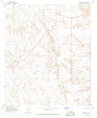
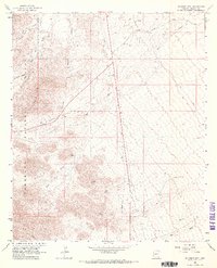
1966 Map of Artesia NE
USGS Topo · Published 1967About this map
The Southern Pacific railroad corridor cuts a sharp line through the desert landscape of Graham County in the mid-1960s, following the path of the San Simon River. This arid terrain is defined by complex drainage systems, including Oak Draw and the descriptively named Slick Rock Wash. Human presence is sparse, centered primarily on infrastructure for the railroad and ranching interests, such as a remote Corral and the Rock House settlement located west of the river. The map illustrates a network of Jeep Trails and unimproved dirt roads that provide the only access into the undulating terrain. The proximity of the rail line to the riverbed reflects the historical reliance on natural valleys for transportation routes through this part of Arizona.
Find a feature on this map
10 named features on this map. Tap any name to fly to it.
Don’t see what you’re looking for? This feature index may not catch every label — zoom into the map to look around manually.
Map Details
Editions of this 1966 Artesia NE Map
This is the sole edition of this map. No revisions or reprints were ever made.
Other maps of this area

1954 · Silver City
USGS Topo · 1:250,000

1958 · Silver City
USGS Topo · 1:250,000

1960 · Guthrie
USGS Topo · 1:62,500

1960 · Safford
USGS Topo · 1:62,500

1962 · Silver City
USGS Topo · 1:250,000
1966 · Tanque
USGS Topo · 1:24,000

1966 · Artesia
USGS Topo · 1:24,000
1966 · Javelina Peak
USGS Topo · 1:24,000
1966 · Dry Mountain
USGS Topo · 1:24,000
1966 · Gillespie Mtn.
USGS Topo · 1:24,000