1966 Map of Gillespie Mtn.
USGS Topo · Published 1967About this map
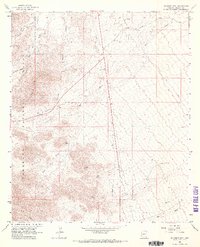
P Ranch and the high peaks of Gillespie Mtn dominate this mid-1960s survey of southeastern Arizona. The landscape is defined by its arid drainages and isolated family holdings, where the Coronado National Forest boundary meets several rural homesteads and points of interest such as Van Gaubig and Baker. This map provides a detailed view of the infrastructure supporting these high-desert outposts, including a prominent Pipeline cutting north-south across the quadrangle and a network of Jeep Trails navigating the complex drainage systems of Oak Draw and Dutch Henry Wash. The mapping of several Water Tanks and a Spring reveals the critical importance of water management in this livestock-grazing environment. This record of the Graham County interior preserves the precise locations of historical ranching developments and topographical landmarks before later modern shifts in land use.
Find a feature on this map
18 named features on this map. Tap any name to fly to it.
Don’t see what you’re looking for? This feature index may not catch every label — zoom into the map to look around manually.
Map Details
Editions of this 1966 Gillespie Mtn. Map
2 editions found
Historical Maps of Graham County Through Time
396 maps found

1938 Galiuro Mts
Graham County, AZ

1938 Klondyke
Graham County, AZ

1940 Sierra Bonita Ranch
Graham County, AZ

1942 Mt. Graham
Graham County, AZ

1942 Sierra Bonita Ranch
Graham County, AZ

1943 Galiuro Mts
Graham County, AZ

1943 Klondyke
Graham County, AZ

1943 Sierra Bonita Ranch
Graham County, AZ

1944 Jackson Mtn.
Graham County, AZ

1945 Mt. Graham
Graham County, AZ

1946 Jackson Mtn.
Graham County, AZ

1960 Guthrie
Graham County, AZ

1962 Bryce Mountain
Graham County, AZ

1962 San Carlos Reservoir
Graham County, AZ

1966 Artesia
Graham County, AZ

1966 Artesia NE
Graham County, AZ

1966 Ash Creek NE
Graham County, AZ

1966 Ash Creek Ranch
Graham County, AZ

1966 Branaman Spring
Graham County, AZ

1966 Bronco Gulch
Graham County, AZ

1966 Dry Mountain
Graham County, AZ

1966 Gillespie Mtn.
Graham County, AZ

1966 Javelina Peak
Graham County, AZ

1966 Mount Triplet
Graham County, AZ

1966 Tanque
Graham County, AZ

1966 Whitlock Cienega
Graham County, AZ

1966 Whitlock Mts. NE
Graham County, AZ

1967 Elwood Canyon
Graham County, AZ

1967 Freezeout Mountain
Graham County, AZ

1967 Natanes Mts NE
Graham County, AZ

1967 Natanes Mts NW
Graham County, AZ

1967 Point of Pines East
Graham County, AZ

1967 Point of Pines West
Graham County, AZ

1967 Sawbuck Mtn.
Graham County, AZ

1967 Tule Tubs
Graham County, AZ

1967 Willow Mtn.
Graham County, AZ

1967 Willow Mtn SE
Graham County, AZ

1972 Bassett Peak
Graham County, AZ

1972 Blue Jay Peak
Graham County, AZ

1972 Booger Canyon
Graham County, AZ

1972 Buford Hill
Graham County, AZ

1972 Cobre Grande Mtn
Graham County, AZ

1972 Eureka Ranch
Graham County, AZ

1972 Fort Grant
Graham County, AZ

1972 Harrison Canyon
Graham County, AZ

1972 Jackson Mtn.
Graham County, AZ

1972 Kennedy Peak
Graham County, AZ

1972 Kielberg Canyon
Graham County, AZ

1972 Klondyke
Graham County, AZ

1972 Mt. Graham
Graham County, AZ

1972 Oak Grove Canyon
Graham County, AZ

1972 Rhodes Peak
Graham County, AZ

1972 Sierra Bonita Ranch
Graham County, AZ

1972 Stockton Pass
Graham County, AZ

1972 Telegraph Wash
Graham County, AZ

1972 Tripp Canyon
Graham County, AZ

1972 Webb Peak
Graham County, AZ

1976 Elwood Canyon
Graham County, AZ

1985 Eden
Graham County, AZ

1985 Gila Box
Graham County, AZ

1985 Lone Star Mountain
Graham County, AZ

1985 Shingle Mill Mountain
Graham County, AZ

1985 Tollgate Tank
Graham County, AZ

1985 Weber Peak
Graham County, AZ

1986 Ash Peak
Graham County, AZ

1989 Beargrass Basin
Graham County, AZ

1989 Bonita Spring
Graham County, AZ

1989 Bonita Tank
Graham County, AZ

1989 Bryce Mountain
Graham County, AZ

1989 Calva
Graham County, AZ

1989 Dewey Flat
Graham County, AZ

1989 Elevator Mountain
Graham County, AZ

1989 Geronimo
Graham County, AZ

1989 Gila Peak
Graham County, AZ

1989 Markham Creek
Graham County, AZ

1989 Park Creek Cabins
Graham County, AZ

1989 Rawhide Mountain
Graham County, AZ

1989 San Carlos Reservoir
Graham County, AZ

1996 Artesia
Graham County, AZ

1996 Bassett Peak
Graham County, AZ

1996 Blue Jay Peak
Graham County, AZ

1996 Eureka Ranch
Graham County, AZ

1996 Fort Grant
Graham County, AZ

1996 Gillespie Mountain
Graham County, AZ

1996 Harrison Canyon
Graham County, AZ

1996 Kennedy Peak
Graham County, AZ

1996 Kielberg Canyon
Graham County, AZ

1996 Mount Graham
Graham County, AZ

1996 Oak Grove Canyon
Graham County, AZ

1996 Rhodes Peak
Graham County, AZ

1996 Sierra Bonita Ranch
Graham County, AZ

1996 Stockton Pass
Graham County, AZ

1996 Webb Peak
Graham County, AZ

1997 Beargrass Basin
Graham County, AZ

1997 Buford Hill
Graham County, AZ

1997 Jackson Mountain
Graham County, AZ

1997 Shingle Mill Mountain
Graham County, AZ

1997 Tripp Canyon
Graham County, AZ

1998 Cobre Grande Mountain
Graham County, AZ

1998 Klondyke
Graham County, AZ

1998 Mount Turnbull
Graham County, AZ

2011 Artesia
Graham County, AZ

2011 Artesia NE
Graham County, AZ

2011 Ash Creek NE
Graham County, AZ

2011 Ash Creek Ranch
Graham County, AZ

2011 Ash Peak
Graham County, AZ

2011 Bassett Peak
Graham County, AZ

2011 Beargrass Basin
Graham County, AZ

2011 Blue Jay Peak
Graham County, AZ

2011 Bonita Spring
Graham County, AZ

2011 Bonita Tank
Graham County, AZ

2011 Booger Canyon
Graham County, AZ

2011 Branaman Spring
Graham County, AZ

2011 Bronco Gulch
Graham County, AZ

2011 Bryce Mountain
Graham County, AZ

2011 Buford Hill
Graham County, AZ

2011 Calva
Graham County, AZ

2011 Cobre Grande Mountain
Graham County, AZ

2011 Dewey Flat
Graham County, AZ

2011 Dry Mountain
Graham County, AZ

2011 Eden
Graham County, AZ

2011 Elevator Mountain
Graham County, AZ

2011 Elwood Canyon
Graham County, AZ

2011 Eureka Ranch
Graham County, AZ

2011 Fort Grant
Graham County, AZ

2011 Freezeout Mountain
Graham County, AZ

2011 Geronimo
Graham County, AZ

2011 Gila Box
Graham County, AZ

2011 Gila Peak
Graham County, AZ

2011 Gillespie Mountain
Graham County, AZ

2011 Harrison Canyon
Graham County, AZ

2011 Jackson Mountain
Graham County, AZ

2011 Javelina Peak
Graham County, AZ

2011 Kennedy Peak
Graham County, AZ

2011 Kielberg Canyon
Graham County, AZ

2011 Klondyke
Graham County, AZ

2011 Lone Star Mountain
Graham County, AZ

2011 Markham Creek
Graham County, AZ

2011 Mount Graham
Graham County, AZ

2011 Mount Triplet
Graham County, AZ

2011 Mount Turnbull
Graham County, AZ

2011 Natanes Mountains NE
Graham County, AZ

2011 Natanes Mountains NW
Graham County, AZ

2011 Oak Grove Canyon
Graham County, AZ

2011 Park Creek Cabins
Graham County, AZ

2011 Point of Pines East
Graham County, AZ

2011 Point of Pines West
Graham County, AZ

2011 Rawhide Mountain
Graham County, AZ

2011 Rhodes Peak
Graham County, AZ

2011 San Carlos Reservoir
Graham County, AZ

2011 Sawbuck Mountain
Graham County, AZ

2011 Shingle Mill Mountain
Graham County, AZ

2011 Sierra Bonita Ranch
Graham County, AZ

2011 Stockton Pass
Graham County, AZ

2011 Tanque
Graham County, AZ

2011 Telegraph Wash
Graham County, AZ

2011 Tollgate Tank
Graham County, AZ

2011 Tripp Canyon
Graham County, AZ

2011 Tule Tubs
Graham County, AZ

2011 Webb Peak
Graham County, AZ

2011 Weber Peak
Graham County, AZ

2011 Whitlock Cienega
Graham County, AZ

2011 Whitlock Mountains NE
Graham County, AZ

2011 Willow Mountain
Graham County, AZ

2011 Willow Mountain SE
Graham County, AZ

2014 Artesia
Graham County, AZ

2014 Artesia NE
Graham County, AZ

2014 Ash Creek NE
Graham County, AZ

2014 Ash Creek Ranch
Graham County, AZ

2014 Ash Peak
Graham County, AZ

2014 Bassett Peak
Graham County, AZ

2014 Beargrass Basin
Graham County, AZ

2014 Blue Jay Peak
Graham County, AZ

2014 Bonita Spring
Graham County, AZ

2014 Bonita Tank
Graham County, AZ

2014 Booger Canyon
Graham County, AZ

2014 Branaman Spring
Graham County, AZ

2014 Bronco Gulch
Graham County, AZ

2014 Bryce Mountain
Graham County, AZ

2014 Buford Hill
Graham County, AZ

2014 Calva
Graham County, AZ

2014 Cobre Grande Mountain
Graham County, AZ

2014 Dewey Flat
Graham County, AZ

2014 Dry Mountain
Graham County, AZ

2014 Eden
Graham County, AZ

2014 Elevator Mountain
Graham County, AZ

2014 Elwood Canyon
Graham County, AZ

2014 Eureka Ranch
Graham County, AZ

2014 Fort Grant
Graham County, AZ

2014 Freezeout Mountain
Graham County, AZ

2014 Geronimo
Graham County, AZ

2014 Gila Box
Graham County, AZ

2014 Gila Peak
Graham County, AZ

2014 Gillespie Mountain
Graham County, AZ

2014 Harrison Canyon
Graham County, AZ

2014 Jackson Mountain
Graham County, AZ

2014 Javelina Peak
Graham County, AZ

2014 Kennedy Peak
Graham County, AZ

2014 Kielberg Canyon
Graham County, AZ

2014 Klondyke
Graham County, AZ

2014 Lone Star Mountain
Graham County, AZ

2014 Markham Creek
Graham County, AZ

2014 Mount Graham
Graham County, AZ

2014 Mount Triplet
Graham County, AZ

2014 Mount Turnbull
Graham County, AZ

2014 Natanes Mountains NE
Graham County, AZ

2014 Natanes Mountains NW
Graham County, AZ

2014 Oak Grove Canyon
Graham County, AZ

2014 Park Creek Cabins
Graham County, AZ

2014 Point of Pines East
Graham County, AZ

2014 Point of Pines West
Graham County, AZ

2014 Rawhide Mountain
Graham County, AZ

2014 Rhodes Peak
Graham County, AZ

2014 San Carlos Reservoir
Graham County, AZ

2014 Sawbuck Mountain
Graham County, AZ

2014 Shingle Mill Mountain
Graham County, AZ

2014 Sierra Bonita Ranch
Graham County, AZ

2014 Stockton Pass
Graham County, AZ

2014 Tanque
Graham County, AZ

2014 Telegraph Wash
Graham County, AZ

2014 Tollgate Tank
Graham County, AZ

2014 Tripp Canyon
Graham County, AZ

2014 Tule Tubs
Graham County, AZ

2014 Webb Peak
Graham County, AZ

2014 Weber Peak
Graham County, AZ

2014 Whitlock Cienega
Graham County, AZ

2014 Whitlock Mountains NE
Graham County, AZ

2014 Willow Mountain
Graham County, AZ

2014 Willow Mountain SE
Graham County, AZ

2018 Artesia
Graham County, AZ

2018 Artesia NE
Graham County, AZ

2018 Ash Creek NE
Graham County, AZ

2018 Ash Creek Ranch
Graham County, AZ

2018 Ash Peak
Graham County, AZ

2018 Bassett Peak
Graham County, AZ

2018 Beargrass Basin
Graham County, AZ

2018 Blue Jay Peak
Graham County, AZ

2018 Bonita Spring
Graham County, AZ

2018 Bonita Tank
Graham County, AZ

2018 Booger Canyon
Graham County, AZ

2018 Branaman Spring
Graham County, AZ

2018 Bronco Gulch
Graham County, AZ

2018 Bryce Mountain
Graham County, AZ

2018 Buford Hill
Graham County, AZ

2018 Calva
Graham County, AZ

2018 Cobre Grande Mountain
Graham County, AZ

2018 Dewey Flat
Graham County, AZ

2018 Dry Mountain
Graham County, AZ

2018 Eden
Graham County, AZ

2018 Elevator Mountain
Graham County, AZ

2018 Elwood Canyon
Graham County, AZ

2018 Eureka Ranch
Graham County, AZ

2018 Fort Grant
Graham County, AZ

2018 Freezeout Mountain
Graham County, AZ

2018 Geronimo
Graham County, AZ

2018 Gila Box
Graham County, AZ

2018 Gila Peak
Graham County, AZ

2018 Gillespie Mountain
Graham County, AZ

2018 Harrison Canyon
Graham County, AZ

2018 Jackson Mountain
Graham County, AZ

2018 Javelina Peak
Graham County, AZ

2018 Kennedy Peak
Graham County, AZ

2018 Kielberg Canyon
Graham County, AZ

2018 Klondyke
Graham County, AZ

2018 Lone Star Mountain
Graham County, AZ

2018 Markham Creek
Graham County, AZ

2018 Mount Graham
Graham County, AZ

2018 Mount Triplet
Graham County, AZ

2018 Mount Turnbull
Graham County, AZ

2018 Natanes Mountains NE
Graham County, AZ

2018 Natanes Mountains NW
Graham County, AZ

2018 Oak Grove Canyon
Graham County, AZ

2018 Park Creek Cabins
Graham County, AZ

2018 Point of Pines East
Graham County, AZ

2018 Point of Pines West
Graham County, AZ

2018 Rawhide Mountain
Graham County, AZ

2018 Rhodes Peak
Graham County, AZ

2018 San Carlos Reservoir
Graham County, AZ

2018 Sawbuck Mountain
Graham County, AZ

2018 Shingle Mill Mountain
Graham County, AZ

2018 Sierra Bonita Ranch
Graham County, AZ

2018 Stockton Pass
Graham County, AZ

2018 Tanque
Graham County, AZ

2018 Telegraph Wash
Graham County, AZ

2018 Tollgate Tank
Graham County, AZ

2018 Tripp Canyon
Graham County, AZ

2018 Tule Tubs
Graham County, AZ

2018 Webb Peak
Graham County, AZ

2018 Weber Peak
Graham County, AZ

2018 Whitlock Cienega
Graham County, AZ

2018 Whitlock Mountains NE
Graham County, AZ

2018 Willow Mountain
Graham County, AZ

2018 Willow Mountain SE
Graham County, AZ

2021 Artesia
Graham County, AZ

2021 Artesia NE
Graham County, AZ

2021 Ash Creek NE
Graham County, AZ

2021 Ash Creek Ranch
Graham County, AZ

2021 Ash Peak
Graham County, AZ

2021 Bassett Peak
Graham County, AZ

2021 Beargrass Basin
Graham County, AZ

2021 Blue Jay Peak
Graham County, AZ

2021 Bonita Spring
Graham County, AZ

2021 Bonita Tank
Graham County, AZ

2021 Booger Canyon
Graham County, AZ

2021 Branaman Spring
Graham County, AZ

2021 Bronco Gulch
Graham County, AZ

2021 Bryce Mountain
Graham County, AZ

2021 Buford Hill
Graham County, AZ

2021 Calva
Graham County, AZ

2021 Cobre Grande Mountain
Graham County, AZ

2021 Dewey Flat
Graham County, AZ

2021 Dry Mountain
Graham County, AZ

2021 Eden
Graham County, AZ

2021 Elevator Mountain
Graham County, AZ

2021 Elwood Canyon
Graham County, AZ

2021 Eureka Ranch
Graham County, AZ

2021 Fort Grant
Graham County, AZ

2021 Freezeout Mountain
Graham County, AZ

2021 Geronimo
Graham County, AZ

2021 Gila Box
Graham County, AZ

2021 Gila Peak
Graham County, AZ

2021 Gillespie Mountain
Graham County, AZ

2021 Harrison Canyon
Graham County, AZ

2021 Jackson Mountain
Graham County, AZ

2021 Javelina Peak
Graham County, AZ

2021 Kennedy Peak
Graham County, AZ

2021 Kielberg Canyon
Graham County, AZ

2021 Klondyke
Graham County, AZ

2021 Lone Star Mountain
Graham County, AZ

2021 Markham Creek
Graham County, AZ

2021 Mount Graham
Graham County, AZ

2021 Mount Triplet
Graham County, AZ

2021 Mount Turnbull
Graham County, AZ

2021 Natanes Mountains NE
Graham County, AZ

2021 Natanes Mountains NW
Graham County, AZ

2021 Oak Grove Canyon
Graham County, AZ

2021 Park Creek Cabins
Graham County, AZ

2021 Point of Pines East
Graham County, AZ

2021 Point of Pines West
Graham County, AZ

2021 Rawhide Mountain
Graham County, AZ

2021 Rhodes Peak
Graham County, AZ

2021 San Carlos Reservoir
Graham County, AZ

2021 Sawbuck Mountain
Graham County, AZ

2021 Shingle Mill Mountain
Graham County, AZ

2021 Sierra Bonita Ranch
Graham County, AZ

2021 Stockton Pass
Graham County, AZ

2021 Tanque
Graham County, AZ

2021 Telegraph Wash
Graham County, AZ

2021 Tollgate Tank
Graham County, AZ

2021 Tripp Canyon
Graham County, AZ

2021 Tule Tubs
Graham County, AZ

2021 Webb Peak
Graham County, AZ

2021 Weber Peak
Graham County, AZ

2021 Whitlock Cienega
Graham County, AZ

2021 Whitlock Mountains NE
Graham County, AZ

2021 Willow Mountain
Graham County, AZ

2021 Willow Mountain SE
Graham County, AZ

2023 Beargrass Basin
Graham County, AZ

2023 Kennedy Peak
Graham County, AZ

2023 Klondyke
Graham County, AZ

2023 Mount Turnbull
Graham County, AZ

2023 Natanes Mountains NW
Graham County, AZ

2023 Rawhide Mountain
Graham County, AZ

2023 San Carlos Reservoir
Graham County, AZ

2023 Shingle Mill Mountain
Graham County, AZ

2026 Ash Creek NE
Graham County, AZ

2026 Ash Creek Ranch
Graham County, AZ

2026 Bassett Peak
Graham County, AZ

2026 Bonita Spring
Graham County, AZ

2026 Bonita Tank
Graham County, AZ

2026 Booger Canyon
Graham County, AZ

2026 Branaman Spring
Graham County, AZ

2026 Bronco Gulch
Graham County, AZ

2026 Bryce Mountain
Graham County, AZ

2026 Buford Hill
Graham County, AZ

2026 Calva
Graham County, AZ

2026 Cobre Grande Mountain
Graham County, AZ

2026 Dewey Flat
Graham County, AZ

2026 Elevator Mountain
Graham County, AZ

2026 Eureka Ranch
Graham County, AZ

2026 Fort Grant
Graham County, AZ

2026 Geronimo
Graham County, AZ

2026 Gila Box
Graham County, AZ

2026 Gila Peak
Graham County, AZ

2026 Harrison Canyon
Graham County, AZ

2026 Jackson Mountain
Graham County, AZ

2026 Kennedy Peak
Graham County, AZ

2026 Kielberg Canyon
Graham County, AZ

2026 Klondyke
Graham County, AZ

2026 Markham Creek
Graham County, AZ

2026 Mount Triplet
Graham County, AZ

2026 Oak Grove Canyon
Graham County, AZ

2026 Park Creek Cabins
Graham County, AZ

2026 Rhodes Peak
Graham County, AZ

2026 Sierra Bonita Ranch
Graham County, AZ

2026 Tule Tubs
Graham County, AZ