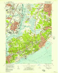
1955 Map of Arthur Kill
USGS Topo · Published 1957About this map
Arthur Kill serves as the industrial and maritime spine of this mid-1950s survey, separating the dense refineries and rail yards of Linden and Carteret, New Jersey, from the varied landscape of Staten Island. The New Jersey side is dominated by heavy infrastructure, including the Central RR of New Jersey and the newly constructed New Jersey Turnpike. Across the water, Staten Island displays a mix of growing residential hubs like Eltingville and Great Kills alongside large institutional footprints such as the Sea View Hospital and the Richmond State School. The map captures the island's aviation history via the Staten Island Airport and the Linden Airport across the reach. Significant genealogical detail is present in the numerous burial grounds, including the Baron Hirsch Cemetery and United Hebrew Cemetery, while the presence of the Mount Loretto Boys Home and various seminaries reflects the region's strong social and religious foundations during this period of post-war expansion.
Find a feature on this map
125 named features on this map. Tap any name to fly to it.
Don’t see what you’re looking for? This feature index may not catch every label — zoom into the map to look around manually.
Map Details
Editions of this 1955 Arthur Kill Map
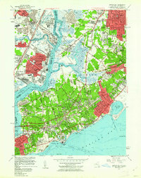
2 editions found
Other maps of this area

1888 · Plainfield
USGS Topo · 1:62,500

1888 · New Brunswick
USGS Topo · 1:62,500

1888 · Sandy Hook
USGS Topo · 1:62,500

1893 · New Brunswick
USGS Topo · 1:62,500

1893 · Plainfield
USGS Topo · 1:62,500

1893 · Sandy Hook
USGS Topo · 1:62,500

1898 · Plainfield
USGS Topo · 1:62,500

1898 · Staten Island
USGS Topo · 1:62,500

1900 · Passaic
USGS Topo · 1:125,000

1900 · Staten Island
USGS Topo · 1:62,500