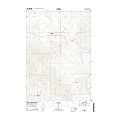
2015 Map of Arvada
USGS Topo · Published 2015About this map
Arvada sits at the confluence of the Powder River and Clear Creek, serving as a focal point for this Sheridan County landscape. The settlement pattern is defined by the proximity to these vital water sources and the path of Us 14-16, which cuts through the northern half of the quadrangle. North of the town, the small settlement of Kendrick is situated among several named geographic features, including Weller Reservoir and Lake Draw. The terrain is deeply incised by a network of ephemeral drainages such as Hando Draw and Campbell Draw, reflecting the arid and highly eroded character of the Powder River Basin. Local road networks like Arvada Davis Rd and Crossing Rd provide access through the township boundaries of T55N and T54N, while water management features like Puffball Reservoir indicate the region's reliance on collected runoff for ranching or agricultural operations.
Find a feature on this map
27 named features on this map. Tap any name to fly to it.
Don’t see what you’re looking for? This feature index may not catch every label — zoom into the map to look around manually.
Map Details
Editions of this 2015 Arvada Map
This is the sole edition of this map. No revisions or reprints were ever made.
Other maps of this area

1955 · Sheridan
USGS Topo · 1:250,000

1958 · Sheridan
USGS Topo · 1:250,000

1962 · Sheridan
USGS Topo · 1:250,000

1971 · Cabin Creek SE
USGS Topo · 1:24,000

1971 · Arvada
USGS Topo · 1:24,000

1971 · Gardner Gulch
USGS Topo · 1:24,000
1971 · Fawn Draw
USGS Topo · 1:24,000

1971 · Leiter
USGS Topo · 1:24,000
1971 · Arvada NE
USGS Topo · 1:24,000
1972 · Lariat
USGS Topo · 1:24,000